UPRAN (Pacifica)
United Provinces of Rhayna, Alla-gy and Néa-gy Ηνωμένες Επαρχίες του Ράινα, Αλλα-Γη και Νέα-Γη | |
|---|---|
Motto: Long Life Us All Mάκρος ζωή Μας Ολοι | |
Anthem: Monopáti gia Ólous Μονοπάτι για Óλους | |
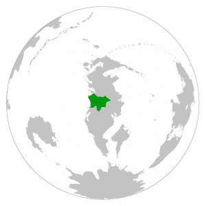
 Location of Rhayna in the South Pacific | |
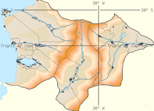
 Closeup of Rhayna | |
| Capital | Pzárya |
| Largest city | Rouketá |
| Official languages | Aegean |
| Recognised national languages | Aegean |
| Sign languages | Aegean Sign Language Νοηματική Γλώσσα Αιγαίο (ΝΓA/NGA) |
| Ethnic groups (2022 census) | 18.67% Rhaynans 7.82% Alla-gyans 73.43% Néa-gyans 0.08% Romordians |
| Religion (2022 census) | 49.0% Religious 49.1% No religion 1.9% Unanswered |
| Demonym(s) | Rhaynan |
| Government | Federal democratic presidential constitutional republic |
• Prytanis of Rhayna | Boutros Georgiou |
• Viceprytanis of Rhayna | Gisella de Luca |
• Prytanis of Rhayna's Chamber of Deputies | Aria Iliadis |
• Archigós of the Konkrésou | Fabiano Marchesi |
• Archigós of Justice | Markos Christellis |
| Legislature | Genikés Kámeres |
| The Konkrésou | |
| The Rhaynan Voulí | |
| Federal independent republic | |
• Unification of most Rhaynan city states | 1100 BC |
• Galaniades dynasty | 1100 BC-894 BC |
• Strateas dynasty | 894 BC-387 BC |
• Loreas dynasty | 387 BC-35 AD |
• Lagatos dynasty | 35 AD-224 AD |
• Zerveas dynasty | 224 AD-326 AD |
• Remeas dynasty | 326 AD-812 AD |
• Moneli dynasty | 812 AD-1347 AD |
• Echemmon dynasty | 1347-1588 |
• Akadios dynasty | 1588-1736 |
• Calypso dynasty | 1736-1789 |
• Hyrmina dynasty | 2 July, 1789-1871 |
• The Eminent Thirteen's Regency | 18 December, 1871-1884 |
• Aglaia dynasty | 4 December, 1884-1907 |
• The Ternary Republics | 12 June, 1907-1923 |
• The Gennaíos | 13 April, 1923-1953 |
• The Endiámeso | 13 December, 1953-1965 |
• UPRAN Republic | 6 May, 1965-2021 |
| Area | |
• Total | 931,948 km2 (359,827 sq mi) |
| Population | |
• 2023 estimate | 46,743,205 |
• 2022 census | 44,473,515 |
• Density | 47.72/km2 (123.6/sq mi) |
| GDP (PPP) | 2022 estimate |
• Total | 2.37 trillion |
• Per capita | $53,290.14 |
| GDP (nominal) | 2022 estimate |
• Total | 1.77 trillion |
• Per capita | $39,798.97 |
| Currency | Sigma (SIG) |
| Time zone | UTC-3, -2 (CCT) |
• Summer (DST) | UTC-2, -1 (CCT) |
| Date format | dd/mm/yyyy CE |
| Driving side | right |
| Calling code | +65 |
| World Forum Code | RHA |
| Internet TLD | .rha, .ραι |
Rhayna (Aegean: Ράινα, Aegean pronunciation: [ráina]), United Provinces of Rhayna (Aegean: Ηνωμένες Επαρχίες του Ράινα, Aegean pronunciation: [inoménes eparchíes tou ráina]) or United Provinces of Rhayna, Alla-gy and Nea-gy (Aegean: Ηνωμένες Επαρχίες του Ράινα, Αλλα-Γη και Νέα-Γη, Aegean pronunciation: [inoménes eparchíes tou ráina alla gi kai néa gi]) is a big sized country located in the South Pacific, in the middle of Cordilia, bordered by Qaweritoyu to the north; Past at the northeast; the Valkyrian Republic, Hystaiga and the Federal Union of Kosbareland to the south; and the Cordilian Sea to the west.
Composed of three main parts, Rhayna's territory splits into three states; Rhayna, Alla-gy and Nea-gy, which, in order, enter the interior of the continent from the west to the east. It covers an area of 931,948 square kilometres (359,827 sq mi), and it has mainly an arid climate, with exception to Nea-gy. Nea-gy, thanks to the conjoint actions of Huawan and Rhayna in the reforestation of the Nea-gyan steppe, is seeing yearly augmentation of vegetation cover against the desertification due to the climate change. In the banks of large rivers such as the Tromeros or Apoala, and in the coasts of Lake Kryo, the landscape is mainly composed of formerly flooded grasslands filled with typical wetlands' vegetation. The capital is Pzarya, located in Rhayna at the mouth of the Imisy, and the largest city is Rouketa, with Pzarya just behind.
The earliest evidence of the presence of human ancestors in the Rhaynan Desert, dated to 30,000 BCE, is to be found in the Rhaynan province of Rouketa. Neolithic settlements in Rhayna, dating from the 10th millennium BCE, are some of the oldest in Cordilia, as Rhayna lies mid-way on the migration route of a specific population of aegeans through Central and South Cordilia.
On the world stage, the Republic of Rhayna participated in the Great War in the winning Allied side together with formerly independent aegeans nation against Pruecia and the Father States in the Imperialist side.
Today, Rhayna is a presidential democratic and constitutional republic led by a prytanis. It is a developed nation that offers various welfare services. Although there are regions of pronounced poverty in Rhayna, work is being made for the industrial development of these places. With rising success in Nea-gy, becoming the most industrialized region of Rhayna, and slow advancements in Alla-gy, recovering each year from the Eliánic dictatorship, efforts on rhaynan development has been proving successful since the Rhaynan Civil War. Among its exports are heavy machinery production, semiconductors, steel, nitrogenous fertilizers and oil. In addition, tourism services are offered. The different regions of Rhayna have limited autonomy in their decisions.
Etymology
Rhayna's name has been distorted over the years, although in Aegean it can still be translated as “rain”, which is strange considering the main climate. Theories hold that civilization grew on the shores of lake Kryo, which would release large amounts of moisture into the air that would fall as rain, which would explain in a certain part the ironic name.
History
Prehistory and early history

The earliest evidence of the presence of human ancestors in the Rhaynan Desert, dated to 30,000 BCE, is to be found in the Soria Remains, in the Rhaynan province of Rouketa. All three stages of the Stone Age (Palaeolithic, Mesolithic, and Neolithic) are represented in Rhayna, for example in the Osta Cave, in Mt. Atzali. Neolithic settlements in Rhayna, dating from the 10th millennium BCE, are some of the oldest in Cordilia, as Rhayna lies mid-way on the migration route of a specific population of aegeans through Central and South Cordilia.
Following the end of the Rhaynan Neolithic period and the Lost Age in 3,200 BCE, a slow transition period between the stone economy to the bronze economy produced during the end of the 4th Millennium BCE. The apparition of Corenian and Odymnan cultures in the mouth of the Imisy; Godosian Culture in the Delta of the Tromeros; Crotissan, Kamareucian and Phocanean cultures in the Kalythean island; and Hyeleran, Aegenaean, Mylyrian, Lariteian, Sicatrean, Nysatrean and Salenian cultures around Lake Kryo. The first large buildings (Sitonion Palace) were built by each city state and their colonies until the start of the 1st Millennium BCE, when the majority of city states that were once separated were united by Timoleon VI.
In Rhayna, the Godosian, Corenian, and Kalythean city states are considered as the main theatres of developments of the Rhaynan civilization. These civilizations possessed writing, all of them sharing local variations of Aegean script, while the Godosians gradually absorbed the Salenian. Still, with this civilizations being the main powers of the military and economic landscape of the water shores of Rhayna, they fell and raised back many times until the unification of the majority of this. Many of the writings dating before the 1100 BCE were lost or had oral reinterpretations of them.
Geography
Rhayna lies primarily between latitudes -30º and -19ºN, and longitudes -39.5º and -25ºE. At 931,948 square kilometres (359,827 sq mi), it's one of the biggest countries in the South Pacific. Due to the extreme aridity of Rhayna's and Alla-gy's climate, population centres are concentrated on the narrow rivers valleys, deltas, and the state of Nea-gy.
Rhayna borders to the north by Qaweritoyu, to the northeast by Past, to the south by the Valkyrian Republic, Hystaiga and the Federal Union of Kosbareland, and to the west by the Cordilian Sea.
Apart from the valleys of the major rivers and Néa-gy, the majority of Rhayna's landscape is desert, with a few oases scattered about. Winds create prolific sand dunes that peak at more than 25 metres (82 ft) high in Rhayna, while in Alla-gy dunes barely reach the 5 metres (16 ft) due to the surrounding mountains. This combination of geographic factors contributed to a rather untouched rhaynan territory for most of its history, protecting it from invasions. Although, it also contributed to a noticeable isolation from international events until very recently in the last decades, the only cases of contact being in Rhaynan ports and the north of Nea-gy. The most clear case of this are the territories of the state of Alla-gy, being surrounded by two mountain chains and a desert. This also made for a rather late union of the objectively closely related populations of Rhayna, Alla-gy, and Nea-gy, and only uniting completely in 1965, even though they share language, religion, and most of their cultural activities.
Towns and cities include Parathyro; Ploio; Porta; Ryzi; Xeno; Pzarya, the actual capital; Thymiama; Nadena; Ippeas; Xenica; Tyri; Nkouver; Frachti Kuovale; Chrysi Thea; Asteria; Reton; Eklose; Rouketa; Antitheto; Ouman; Figouras; Kokaliaris; Stemma; and Bizelia in Rhayna; Ypsilos; Ntrouorora; Ontopoli; Ichlyria; Krinos; Kleise; Archaios; and Ypo in Alla-gy; and Oros; Tento; Voreios; Koila; Enois; Ourona; Pantoupoli; and Notos in Nea-gy.
Climate
Most of Rhayna's rain falls in the summer months, although most of them concentrate in the state of Nea-gy, with an average of 70 centimetres (28 in) to 180 centimetres (71 in) for over 90% of the area per year. In Rhayna, the precipitations average 2 millimetres (0.079 in) to 5 millimetres (0.20 in) per year in the driest regions, although along river beds and the coastlines of Lake Kryo the rainfall can be as high as 400 millimetres (16 in). Alla-gy is the driest state of the union, with precipitations of just around 2 millimetres for most of the territory. As such, the population relies on water sources such as lakes, rivers, springs, and oases for farming, human consumption, industry, etc.
Snow falls in the tops of the Defteros and Prostasia ranges, and frost is known to appear in the higher river locations due to the low temperatures the deserts and savannah reach.
Rhayna is one of the driest and hottest nations in the region of the South Pacific, hosting two major deserts (the Rhaynan and Alla-gyan Deserts) completely inside its borders. Rhayna has a characteristic hot, sunny and dry climate. Average high temperatures are high in the west and east, but very to extremely high in the rest of the interior of the country during winter. The cold western Cordilian sea constantly bathes the waters of Rhayna, while the southern trade winds constantly sucks moisture from the Rhaynan Desert towards the Cordilian Sea. The Kallinos is a hot, dry wind that originates from the deserts in the east of the Rhaynan Desert and blows in the autumn or in the early winter. It brings scorching sand and dust particles, and usually brings daytime temperatures over 40 °C (104 °F) and sometimes over 45 °C (113 °F) in the interior, while the relative humidity can drop to 5% or even less. The absolute highest temperatures in Rhayna occur when the Kallinos blows. The weather is almost always sunny and clear in Rhayna except in the summer rainfalls in Nea-gy, where for long periods of the time the sky can be covered in clouds.
Prior to the construction of various dams in the major rivers of UPRAN, these water currents would flood the relatively flat valleys of the territory, bringing with it rich soils. In Rhaynan Mythology there are various gods that occupy of bringing the flood seasons to the river beds, which still today in some regions of Alla-gy and Nea-gy are venerated.

