Geography of Pyhdon-Falistrica (Pacifica): Difference between revisions
No edit summary |
No edit summary |
||
| (5 intermediate revisions by the same user not shown) | |||
| Line 1: | Line 1: | ||
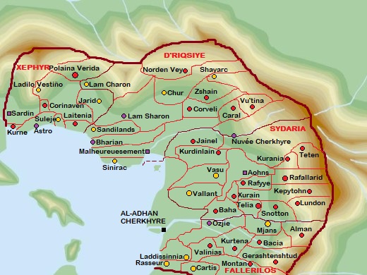
{{Infobox country geography|name=[[Pyhdon-Falistríca (Pacifica)|Pyhdon-Falistríca]]|map= | {{Infobox country geography|name=[[Pyhdon-Falistríca (Pacifica)|Pyhdon-Falistríca]]|map=Aa.jpg|map size=500px|map_alt=|continent=[[South Pacific (Pacifica)|South Pacific]]|region=[[Cordilia (Pacifica)|Cordilia]]|coordinates=<!-- Use {{Coord}} -->|area ranking=17|km area=198233|miles area=|percent land=|percent water=|km coastline=|miles coastline=|exclusive economic zone=Frastinia|borders=Besern, Holy Free, Eflad, Ginalta|highest point=Mt. Ilos at 3084m|lowest point=|longest river=Malheur River at 2781km|largest lake=Poweradham Lake (top of Malheur River) at 78km2|climate=Tropical Rainforest|terrain=|natural resources=Uranium, Gold, Iron, Copper, etc.|natural hazards=|environmental issues=}} | ||
The '''Geography of Pyhdon-Falistrica''' covers the area in the bays of Cherkhyre, Astro and Sement, and the mountainous surroundings | The '''Geography of Pyhdon-Falistrica''' covers the area in the bays of Cherkhyre, Astro and Sement, and the mountainous surroundings | ||
| Line 7: | Line 7: | ||
== Physical geography == | == Physical geography == | ||
=== Tempmap === | |||
[[File:Tempmap.jpg|400x400px|Temperature Map of Pyhdon]] | [[File:Tempmap.jpg|400x400px|Temperature Map of Pyhdon]] | ||
| Line 20: | Line 22: | ||
Green = <10C | Green = <10C | ||
=== Heightmap === | |||
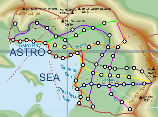
[[File:Pyheight.png|frameless|600x600px]] | |||
== Political geography == | == Political geography == | ||
| Line 863: | Line 868: | ||
|Ladilo Vestiño | |Ladilo Vestiño | ||
|LDVÑ | |LDVÑ | ||
| | |PZD | ||
| | | | ||
|- | |- | ||
Latest revision as of 21:26, 20 November 2024
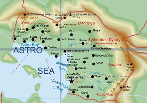 | |
| Continent | South Pacific |
|---|---|
| Region | Cordilia |
| Area | Ranked 17 |
| • Total | 198,233 km2 (76,538 sq mi) |
| Borders | Besern, Holy Free, Eflad, Ginalta |
| Highest point | Mt. Ilos at 3084m |
| Longest river | Malheur River at 2781km |
| Largest lake | Poweradham Lake (top of Malheur River) at 78km2 |
| Climate | Tropical Rainforest |
| Natural Resources | Uranium, Gold, Iron, Copper, etc. |
| Exclusive economic zone | Frastinia |
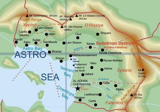
The Geography of Pyhdon-Falistrica covers the area in the bays of Cherkhyre, Astro and Sement, and the mountainous surroundings
Climate
Pyhdon is a mostly tropical area, with mountains encompassing the borders and there being many lakes.
Physical geography
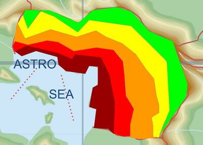
Tempmap
Average:
Dark Red = >25C
Red = >20C
Orange = >15C
Yellow = >10C
Green = <10C
Heightmap
Political geography
States
Admin Districts
Infrastructures
Pyhdon is a well-served nation in terms of Highways and Rail. It has a lot of Railways and quite a few Highways
Highways
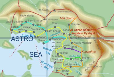
There are 5 Major and 22 Minor Highways in Pyhdon. The major highways will be named Į-X (Įterwas is the word for Highway in Sydadysh) and the minor Į-Xx
List of Highways
| Identification | Name | Color |
|---|---|---|
| Į-1 | Blearics | Cyan |
| Į-2 | Saris | Yellow |
| Į-3 | Raydanr | Orange |
| Į-4 | Vassa | Purple |
| Į-5 | Ojasi | Green |
National Roads
There are a lot of National Roads in Pyhdon-Falistrica, which often connect to Highways. Here is a list. Road names are noted as :
N/[shortname]
| Name | Notation | Number | Running City |
|---|---|---|---|
| Luxembørg Avenue | N/Lxmbr | 001 | Al-Adhan Cherkhyre |
| Marasidayc Avenue | N/Mrsdc | 002 | Malheureuesement |
| Vayaunarias Avenue | N/Vynrs | 003 | Vallant |
| Connoisseur Avenue | N/Cnnss | 004 | Rasseur |
| Caradilesci Avenue | N/Crdsc | 005 | Cartis |
| Ladissinia Avenue | N/Ldssn | 006 | Ladisinnia |
| Mjastanik Avenue | N/Mjstn | 007 | Mjans |
| Ozjie-Aohns Avenue | N/Zjhns | 008 | Ozjie/Aohns |
| Vasunatare Avenue | N/Vsntr | 009 | Vasu |
| Nuvee Malheur Avenue | N/Nvlhr | 010 | Nuvee Malheur |
| Nuvee Cherk Avenue | N/Nvchk | 011 | Nuvee Cherkhyre |
| Xenophobia Avenue | N/Xnphb | 012 | Xarian |
| Shayarc Street | N/Shyrc | 013 | Shayarc |
| Chur Avenue | N/Chrzz | 014 | Chur |
| Saladin Avenue | N/Sldnz | 015 | Lam Sharon Dystrykt |
| SASBS Neuraway | N/Szsbs | 016 | SASBS Group |
Rail network
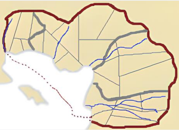
The above image is a map of train lines in Pyhdon.
| Station Number | Coastal | Sydaria | Fallerilos | Aal-Adhan | Masrina | Pyronivelanecia | Grovence | Grisen |
|---|---|---|---|---|---|---|---|---|
| Eflad | Eflad | N/A | N/A | N/A | Eflad | N/A | N/A | |
| 1 | Rasseur | Cartis | Suden | AAC Central | Sandilands | Cartis | Sandilands | Ladilo Vestino |
| 2 | AAC South | Laddissinnia | Kruzer | AAC East | Lam Sharon West | Laddissinnia | Bharian North | Lam Charon |
| 3 | AAC Central | AAC Central | Ozjie Central | Etraltsji | Lam Sharon Central | Etraltsji | Sinirac North | Jarid |
| 4 | AAC North | AAC North | Vasu Central | Ozjie West | Lam Sharon East | Vallant West | Malheureuesement East | Lam Sharon West |
| 5 | Vallant West | Malheureuesement North | Aohns Central | Ozjie Central | Chur West | Aohns Farwest | Vallant East | Lam Sharon Central |
| 6 | Malheureuesement East | Xarian | Nuvee Malheur | Ozjie East | Chur Central | Xarian South | Vallant West | Aohns Farwest |
| 7 | Malheureuesement West | Nuvee Cherkhyre West | Nuvee Cherkhyre Central | Mjans West | Chur East | Xarian | Vasu East | Aohns West |
| 8 | Sinirac East | Nuvee Cherkhyre Central | Nuvee Cherkhyre East | Mjans East | Shayarc | Vasu Central | Aohnvai | |
| 9 | Sinirac Central | Nuvee Cherkhyre East | Mteyser Perc Nationec | Chur Central | Vasu West | Aohns East | ||
| 10 | Bharian | North Lam Sharon | Muraid | Aohns Fareast | ||||
| 11 | Sandilands | Lam Sharon East | ||||||
| 12 | Suleje | Jarid | ||||||
| 13 | Astro | Lam Charon | ||||||
| 14 | Sardin East | Sardin West | ||||||
| 15 | Sardin West | |||||||
| Gianalta | Holy Free | Holy Free | Besern | Holy Free | Gianalta | Besern | Besern |
Harbours
List of Harbours
| City | Area | Name |
|---|---|---|
| Malheureuesement | D'Riqsiye | Malheur-eue-sement Harbour |
| Aal-Adhan Cherkhyre | Fallerilos/Sydaria | Zesty-Cherko-Dhaan Harbour |
| Astro | Xephyr | Astrology Harbour |
| Bharian | D'Riqsiye | Bhar-et Un Port |
| Sinirac | Sin-et-rac Port | |
| Sandilands | Sand Harbour | |
| Suleje | Xephyr | Sledge Harbour |
| Sardin | Pearl Harbour |
Airports
- Main article: Airports of Pyhdon-Falistrica
List of Airports
| Name | City | Pyhdon Air Code | International Air Codes | Megacity IATA/ICAO |
|---|---|---|---|---|
| (AAC) Aeroport de Centr'Un | Aal-Adhan Cherkhyre | AACA | PYA | AAC |
| (AAC) Aeroport de Cent-Deux | AACB | PYB | ||
| (AAC) Aeroport de Cent-Trois | AACC | PYC | ||
| (AAC) Aeroport de Cent-Quatre | AACD | PYD | ||
| (AAC) Aeroport de Centinq | AACE | PYE | ||
| (AAC) Aeroport de Cent-Six | AACF | PYF | ||
| (AAC) Aeroport de Cent-Sept | AACG | PYG | ||
| (AAC) Aeroport de Centuit | AACH | PYH | ||
| (AAC) Aeroport de Centuf | AACI | PYI | ||
| (AAC) Aeroport de Cent-Dix | AACJ | PYJ | ||
| (AAC) Aeroport de Cent-Onze | AACK | PYK | ||
| (AAC) Aeroport de Cent-Douze | AACL | PYL | ||
| (AAC) Aeroport de Cent-Treize | AACM | PYM | ||
| (AAC) Aeroport de Cenqua-Torse | AACN | PYN | ||
| (AAC) Aeroport de Centqui-nze | AACO | PYO | ||
| (AAC) Aeroport de Centsei-ze | AACP | PYP | ||
| (AAC) Aeroport de Cendix-sept | AACQ | PYQ | ||
| (MHM) Aeroport de Malheureuesement | Malheureuesement | MHMA | PYR | MHM |
| (MHM) Sadris Aeroport d'Ouest | MHMB | PYS | ||
| (MHM) Kurencen | MHMC | PYT | ||
| (NVCH) Aeroport de Per'un | Nuvee Cherkhyre | NVCH | PYU | |
| (AHNS) Aeroport de Aohnvai | Aohns | AHNS | PYV | |
| (OZJÏ) Ozjie Aero Kreant | Ozjie | OZJÏ | PYW | |
| (LSHR) Sharon Port | Lam Sharon | LSHR | PYX | |
| (BHRN) Bharenian | Bharian | BHRN | PYY | |
| (ASTR) Astro-nought | Astro | ASTR | PYZ | |
| (LDVÑ) Ladilo Vestiño Airport & Spaceport | Ladilo Vestiño | LDVÑ | PZD | |
| (SRDN) Valaianacis Airport | Sardin | SDNA | PZB | SDN |
| (SRDN) Saliacn Airport | SDNB | PZC |
