Geography of Rhayna (Pacifica): Difference between revisions
Jump to navigation
Jump to search
No edit summary |
No edit summary |
||
| Line 60: | Line 60: | ||
| mark_width = 5 | | mark_width = 5 | ||
| x% = 6.5 | y% = 12 }} | | x% = 6.5 | y% = 12 }} | ||
{{Location mark~ | |||
| width = 500 | |||
| label = [[Nkoúver City (Pacifica)|Nkoúver]] | |||
| position = left | |||
| font_size = 75 | |||
| mark_width = 5 | |||
| x% = 13.5 | y% = 54 }} | |||
{{Location mark~ | |||
| width = 500 | |||
| label = [[Fráchti Quovale City (Pacifica)|Fráchti Quovale]] | |||
| position = top | |||
| font_size = 75 | |||
| mark_width = 5 | |||
| x% = 14 | y% = 53.5 }} | |||
{{Location mark~ | |||
| width = 500 | |||
| label = [[Tyrí City (Pacifica)|Tyrí]] | |||
| position = left | |||
| font_size = 75 | |||
| mark_width = 5 | |||
| x% = 11 | y% = 45 }} | |||
{{Location mark~ | |||
| width = 500 | |||
| label = [[Thymíama City (Pacifica)|Thymíama]] | |||
| position = top | |||
| font_size = 75 | |||
| mark_width = 5 | |||
| x% = 9.5 | y% = 40 }} | |||
{{Location mark~ | |||
| width = 500 | |||
| label = [[Xekína City (Pacifica)|Xekína]] | |||
| position = right | |||
| font_size = 75 | |||
| mark_width = 5 | |||
| x% = 25.5 | y% = 41 }} | |||
{{Location mark~ | |||
| width = 500 | |||
| label = [[Ippéas City (Pacifica)|Ippéas]] | |||
| position = bottom | |||
| font_size = 75 | |||
| mark_width = 5 | |||
| x% = 23 | y% = 41 }} | |||
{{Location mark~ | |||
| width = 500 | |||
| label = [[Nádena City (Pacifica)|Nádena]] | |||
| position = right | |||
| font_size = 75 | |||
| mark_width = 5 | |||
| x% = 16 | y% = 40 }} | |||
{{Location mark~ | |||
| width = 500 | |||
| label = [[Chrysí Theá City (Pacifica)|Chrysí Theá]] | |||
| position = top | |||
| font_size = 75 | |||
| mark_width = 5 | |||
| x% = 21.75 | y% = 53 }} | |||
{{Location mark~ | |||
| width = 500 | |||
| label = [[Astéria City (Pacifica)|Astéria]] | |||
| position = right | |||
| font_size = 75 | |||
| mark_width = 5 | |||
| x% = 21.75 | y% = 53 }} | |||
{{Location mark~ | {{Location mark~ | ||
| Line 118: | Line 181: | ||
| mark_width = 5 | | mark_width = 5 | ||
| x% = 64.5 | y% = 33.5 }} | | x% = 64.5 | y% = 33.5 }} | ||
{{Location mark~ | |||
| width = 500 | |||
| label = [[Tentó City (Pacifica)|Tentó]] | |||
| position = right | |||
| font_size = 75 | |||
| mark_width = 5 | |||
| x% = 73 | y% = 25.5 }} | |||
{{Location mark~ | |||
| width = 500 | |||
| label = [[Voreíos City (Pacifica)|Voreíos]] | |||
| position = right | |||
| font_size = 75 | |||
| mark_width = 5 | |||
| x% = 81 | y% = 25.75 }} | |||
{{Location mark~ | |||
| width = 500 | |||
| label = [[Nótos City (Pacifica)|Nótos]] | |||
| position = right | |||
| font_size = 75 | |||
| mark_width = 5 | |||
| x% = 72.5 | y% = 61 }} | |||
}} | }} | ||
Revision as of 20:02, 3 February 2022
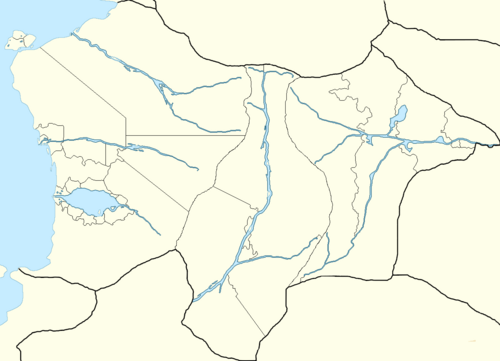
The UPRAN has coastlines on the Cordilian Sea and the rivers Katharístis, Mikrós, Imísy and Trómeros. Rhayna borders to the north by Qaweritoyu and Nori Natto, to the east by the Míkos Valley, to the south by the Valkyrian Republic, Hystaiga and the Federal Union of Kosbareland, and to the west by the Cordilian Sea. Rhayna has an area of 931,948 km² (359,827 sq mi) which makes it one of the biggest countries in the South Pacific.
The longest straight-line distance in Rhayna from north to south is 970 km (603 mi), while that from east to west measures 1,370 km (851 mi). Rhayna has roughly 1,416 km (880 mi) of coastline on the Cordilian Sea. It has an Exclusive Economic Zone of 275,408 km² (106,336 sq mi).
