Kustannuksan colonial empire (Pacifica): Difference between revisions
Jump to navigation
Jump to search
(Created page with "The '''Kustannuksan colonial empire''' constituted the overseas colonies, dependencies, protectorates and territories of the {{Flag|Kustannuksa|name=Kustannuksan Empire}} from 1681 to 1965.") |
No edit summary |
||
| Line 1: | Line 1: | ||
{{Infobox country | |||
|conventional_long_name = Kustannuksan Colonial Empire | |||
|native_name = ''Kustannuksalainen Imperiumi (Kustannan)''<br>''कुस्तन्नुक्सन साम्राज्य (Vedangari)'' | |||
|common_name = Kustannuksa | |||
|status = | |||
|image_flag = [[File:Flag Of Kustannuksa.png|200x200px]] | |||
|flag_type = [[Flag of Kustannuksa (Pacifica)|Flag of Kustannuksa]] | |||
|alt_flag = [[Flag of Kustannuksa (Pacifica)|Flag of Kustannuksa]] | |||
|flag_border = <!--set to no to disable border around the flag--> | |||
|image_flag2 = | |||
|alt_flag2 = <!--alt text for second flag--> | |||
|flag2_border = <!--set to no to disable border around the flag--> | |||
|image_coat = [[File:Kustannuksan Imperial Coat Of Arms.png|200x200px]] | |||
|alt_coat = <!--alt text for coat of arms--> | |||
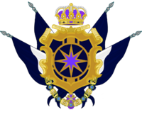
|symbol_type = [[Kustannuksan Imperial Coat Of Arms (Pacifica)|Imperial Coat Of Arms]] | |||
|national_motto = ''"Suuruus seuraa Pohjoistä Tähteä"''<br>''"महत्त्वं उत्तरतारकस्य अनुसरणं करोति"'' | |||
|englishmotto = ''"Greatness follows the Northern Star"'' | |||
|national_anthem = ''"Rule, Kustanna!"'' | |||
|royal_anthem = ''"A golden Star to follow"'' | |||
|other_symbol_type = Imperial Hymn<!--Use if a further symbol exists, e.g. hymn--> | |||
|other_symbol = | |||
|image_map = [[File:Kustannuksan Colonial Empire Map.png|500x500px]] | |||
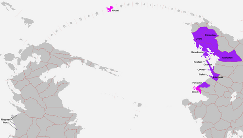
|loctext = Northwest Bailtem<br>Rainbow Islands<br>Western Cordillia. | |||
|alt_map = | |||
|map_caption = Kustannuksan Colonial Empire at its maximum extent in the 19th century.<br>Colonies and dominions in purple.<br>Protectorates in Magenta. | |||
|image_map2 = | |||
|alt_map2 = | |||
|map_caption2 = | |||
|capital = '''[[Pohjoinen (Pacifica)|Pohjoinen]]''' | |||
|coordinates = 2°25'N 25°69'E | |||
|largest_city = capital | |||
|official_languages = '''[[Kustannan (Pacifica)| Kustannan]]'''<br>'''[[Vedangari (Pacifica)| Vedangari]]'''<br> | |||
|national_languages = | |||
|regional_languages = | |||
|languages_type = <!--Use to specify a further type of language, if not official, national or regional--> | |||
|languages = <!--Languages of the further type--> | |||
|languages_sub = <!--Is this further type of language a sub-item of the previous non-sub type? ("yes" or "no")--> | |||
|languages2_type = <!--Another further type of language--> | |||
|languages2 = <!--Languages of this second further type--> | |||
|languages2_sub = <!--Is the second alternative type of languages a sub-item of the previous non-sub type? ("yes" or "no")--> | |||
|ethnic_groups = [[Sjöfolk (Pacifica)|Sjöfolk]]<br>[[Jasiiradaha (Pacifica)|Jasiiradaha]]<br>[[Pahaadche (Pacifica)|Pahaadache]]<br>[[Nehirdoğu (Pacifica)|Nehirdoğu]]<br>[[Nycimbrian (Pacifica)| Nycimbrians]]<br>[[Andrendian (Pacifica)| Andreians]]<br>[[Rhaynans (Pacifica)|Rhaynans]]<br>[[Alla-gyans (Pacifica)|Alla-gyans]]<br>[[Nea-gyans (Pacifica)|Nea-gyans]]<br>[[Denvari (Pacifica)|Denvari]]<br>[[Finixi (Pacifica)|Finixi]]<br>[[Coalitanians (Pacifica)|Coalitanians]] | |||
|ethnic_groups_year = | |||
|ethnic_groups_ref = | |||
|religion = Buddhism<br>Bharaism<br>Mesopoism<br>Celthroicism<br>Christianity<br>Islam<br>Folk Religion<br>Azaelism<br>Other | |||
|religion_year = <!--Year of religion data (if provided)--> | |||
|religion_ref = <!--(for any ref/s to associate with religion data)--> | |||
|demonym = Kustannuksan/Kustannan <!--Term/s describing those associated with the country/territory (e.g. "Belgian" for the country Belgium)--> | |||
|government_type = Federal Constitutional Monarchy | |||
|leader_title1 = Monarchs of the Kustannuksan Empire | |||
|leader_name1 = | |||
|leader_title2 = Imperial Chancellors of Kustannuksa | |||
|leader_name2 = | |||
|leader_title3 = President of the Kustannuksan Imperial Senate | |||
|leader_name3 = | |||
|leader_title4 = Presidents of the Kustannuksan Chamber of Deputies | |||
|leader_name4 = | |||
|leader_title5 = | |||
|leader_name5 = | |||
|legislature = Imperial Parliament | |||
|upper_house = Imperial Senate | |||
|lower_house = Imperial Chamber Of Deputies | |||
|sovereignty_type = | |||
|sovereignty_note = | |||
|established_event1 = Conquest of the Chamak Peninsula. | |||
|established_date1 = 6th March 1681 CE | |||
|established_event2 = Secession of Chamak. | |||
|established_date2 = 28th August 1965 | |||
|established_event3 = | |||
|established_date3 = | |||
|established_event13 = <!--(up to 13 distinct events may be included)--> | |||
|established_date13 = | |||
|area_rank = | |||
|area = <!--Major area size (in [[Template:convert]] either km2 or sqmi first)--> | |||
|area_km2 = 1209506 | |||
|area_sq_mi = 466993 | |||
|area_footnote = <!--Optional footnote for area--> | |||
|percent_water = | |||
|area_label = Total <!--Label under "Area" (default is "Total")--> | |||
|area_label2 = <!--Label below area_label (optional)--> | |||
|area_data2 = <!--Text after area_label2 (optional)--> | |||
|population_estimate = | |||
|population_estimate_rank = | |||
|population_estimate_year = 1900 | |||
|population_census = | |||
|population_census_year = 1900 | |||
|population_density_km2 = | |||
|population_density_sq_mi = | |||
|population_density_rank = | |||
|GDP_PPP = <!--(Gross Domestic Product from Purchasing Power Parity)--> | |||
|GDP_PPP_rank = | |||
|GDP_PPP_year = | |||
|GDP_PPP_per_capita = | |||
|GDP_PPP_per_capita_rank = | |||
|GDP_nominal = | |||
|GDP_nominal_rank = | |||
|GDP_nominal_year = | |||
|GDP_nominal_per_capita = | |||
|GDP_nominal_per_capita_rank = | |||
|Gini = | |||
|Gini_ref = <!--(for any ref/s to associate with Gini number)--> | |||
|Gini_rank = | |||
|Gini_year = | |||
|HDI_year = <!-- Please use the year to which the data refers, not the publication year--> | |||
|HDI = between 0 and 1)--> | |||
|HDI_change = <!--increase/decrease/steady; rank change from previous year--> | |||
|HDI_rank = | |||
|HDI_ref = <!--(for any ref/s to associate with HDI number)--> | |||
|currency = Tähtirah | |||
|currency_code = | |||
|time_zone = UTC | |||
|utc_offset = +2 <!--in the form "+N", where N is number of hours offset--> | |||
|time_zone_DST = <!--Link to DST (Daylight Saving Time) used, otherwise leave empty--> | |||
|utc_offset_DST = <!--in the form "+N", where N is number of hours offset--> | |||
|DST_note = <!--Optional note regarding DST use--> | |||
|antipodes = <!--Place/s exactly on the opposite side of the world to country/territory--> | |||
|date_format = dd/mm/yyyy [[Common Era|CE]] - [[After Empire|AE]] | |||
|drives_on = | |||
|cctld = | |||
|iso3166code = | |||
|calling_code = | |||
|patron_saint = <!--Use patron_saints for multiple--> | |||
|image_map3 = <!--Optional third map position, e.g. for use with reference to footnotes below it--> | |||
|alt_map3 = <!--alt text for third map position--> | |||
|footnote_a = <!--For any footnote <sup>a</sup> used above--> | |||
|footnote_b = <!--For any footnote <sup>b</sup> used above--> | |||
|footnote_h = <!--For any footnote <sup>h</sup> used above--> | |||
|footnotes = <!--For any generic non-numbered footnotes--> | |||
|org_type=Colonial Empire}} | |||
The '''Kustannuksan colonial empire''' constituted the overseas colonies, dependencies, protectorates and territories of the {{Flag|Kustannuksa|name=Kustannuksan Empire}} from 1681 to 1965. | The '''Kustannuksan colonial empire''' constituted the overseas colonies, dependencies, protectorates and territories of the {{Flag|Kustannuksa|name=Kustannuksan Empire}} from 1681 to 1965. | ||
Revision as of 13:15, 3 January 2025
Kustannuksan Colonial Empire Kustannuksalainen Imperiumi (Kustannan) कुस्तन्नुक्सन साम्राज्य (Vedangari) | |
|---|---|
Motto: "Suuruus seuraa Pohjoistä Tähteä" "महत्त्वं उत्तरतारकस्य अनुसरणं करोति" "Greatness follows the Northern Star" | |
Anthem: "Rule, Kustanna!" Royal anthem: "A golden Star to follow" | |
 Kustannuksan Colonial Empire at its maximum extent in the 19th century. Colonies and dominions in purple. Protectorates in Magenta. | |
| Location | Northwest Bailtem Rainbow Islands Western Cordillia. |
| Capital and largest city | Pohjoinen 2°25'N 25°69'E |
| Official languages | Kustannan Vedangari |
| Ethnic groups | Sjöfolk Jasiiradaha Pahaadache Nehirdoğu Nycimbrians Andreians Rhaynans Alla-gyans Nea-gyans Denvari Finixi Coalitanians |
| Religion | Buddhism Bharaism Mesopoism Celthroicism Christianity Islam Folk Religion Azaelism Other |
| Demonym(s) | Kustannuksan/Kustannan |
| Type | Colonial Empire |
| Government | Federal Constitutional Monarchy |
| Legislature | Imperial Parliament |
| Imperial Senate | |
| Imperial Chamber Of Deputies | |
| Establishment | |
• Conquest of the Chamak Peninsula. | 6th March 1681 CE |
• Secession of Chamak. | 28th August 1965 |
| Area | |
• Total | 1,209,506 km2 (466,993 sq mi) |
| HDI | between 0 and 1)--> Error: Invalid HDI value |
| Currency | Tähtirah |
| Time zone | UTC+2 (UTC) |
| Date format | dd/mm/yyyy CE - AE |
The Kustannuksan colonial empire constituted the overseas colonies, dependencies, protectorates and territories of the ![]() Kustannuksan Empire from 1681 to 1965.
Kustannuksan Empire from 1681 to 1965.

