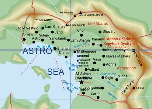
Geography of Pyhdon-Falistrica (Pacifica)
 | |
| Continent | South Pacific |
|---|---|
| Region | Cordilia |
| Area | Ranked 17 |
| • Total | 198,233 km2 (76,538 sq mi) |
| Borders | Besern, Holy Free, Eflad, Ginalta |
| Highest point | Mt. Ilos at 3084m |
| Longest river | Malheur River |
| Climate | Tropical Rainforest |
| Natural Resources | Uranium, Gold, Iron, Copper, etc. |
| Exclusive economic zone | Frastinia |
The Geography of Pyhdon-Falistrica covers the area in the bays of Cherkhyre, Astro and Sement, and the mountainous surroundings
Climate
Physical geography
Branta
Haliétusa
Rubecula
Political geography
Infrastructures
Pyhdon is a well-served nation in terms of Highways and Rail. It has a lot of Railways and quite a few Highways
Highways

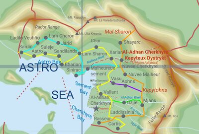
There are 5 Major and 22 Minor Highways in Pyhdon. The major highways will be named Į-X (Įterwas is the word for Highway in Sydadysh) and the minor Į-Xx
List of Highways
| Identification | Name | Color |
|---|---|---|
| Į-1 | Blearics | Cyan |
| Į-2 | Saris | Yellow |
| Į-3 | Raydanr | Orange |
| Į-4 | Vassa | Purple |
| Į-5 | Ojasi | Green |
National Roads
There are a lot of National Roads in Pyhdon-Falistrica, which often connect to Highways. Here is a list. Road names are noted as :
N/[shortname]
| Name | Notation | Number | Running City |
|---|---|---|---|
| Luxembørg Avenue | N/Lxmbr | 001 | Al-Adhan Cherkhyre |
| Marasidayc Avenue | N/Mrsdc | 002 | Malheureuesement |
| Vayaunarias Avenue | N/Vynrs | 003 | Vallant |
| Connoisseur Avenue | N/Cnnss | 004 | Rasseur |
| Caradilesci Avenue | N/Crdsc | 005 | Cartis |
| Ladissinia Avenue | N/Ldssn | 006 | Ladisinnia |
| Mjastanik Avenue | N/Mjstn | 007 | Mjans |
| Ozjie-Aohns Avenue | N/Zjhns | 008 | Ozjie/Aohns |
| Vasunatare Avenue | N/Vsntr | 009 | Vasu |
| Nuvee Malheur Avenue | N/Nvlhr | 010 | Nuvee Malheur |
| Nuvee Cherk Avenue | N/Nvchk | 011 | Nuvee Cherkhyre |
| Xenophobia Avenue | N/Xnphb |
Rail network
Harbours
There are 9 major harbours in Anserisa, 2 are only used for commercial passenger use, 2 are only used for cargo use and 5 are used for both.
List of Harbours
| City | Island | Name | Type |
|---|---|---|---|
| Brantavilla | Branta | Brantavilla Cruise Terminal | Commercial |
| Concordia | Haliétusa | Comto-Marcello I Industrial Harbour | Cargo |
| Vexilla | Rubecula | Vexilla National Harbour | Both |
| Geneva | Branta | Geneva-Brantavilla Cargo Harbour | Cargo |
| Gubernata | Branta | Branta-Aquilono Regional Harbour[1] | Both |
| Libério | Branta | Comto-Libério Regional Harbour | Both |
| Céruléa | Haliétusa | Céruléa Cruise Terminal and Marina | Commercial |
| Statéra | Haliétusa | Statéra-Verbéra Harbour | Both |
| Vergobreta | Rubecula | Vergobreta Regional Harbour | Both |
Airports
- Main article: Airports of Pyhdon-Falistrica
There are 9 airports in Anserisa, 1 International airport, 2 National airports, 1 Regional airport and 5 Municipal airports.
List of Airports
| City | Island | Name | Status |
|---|---|---|---|
| Brantavilla | Branta | Princia-Geneva—Brantavilla | International Airport |
| Concordia | Haliétusa | Comto-Marcello—Concordia | National Airport |
| Vexilla | Rubecula | Vexilla-Opuso | National Airport |
| Chevrona | Branta | Chevrona | Regional Airport |
| Aliquéta | Branta | Branta-Aquilono | Municipal Airport |
| Avisa | Branta | Alisa-Avisa | Municipal Airport |
| Céruléa | Haliétusa | Duchy of Céruléa | Municipal Airport |
| Concilio | Rubecula | Concilio-Vergobreta | Municipal Airport |
| Potissima | Branta | Potissima | Municipal Airport |
Natural hazards
Environmental issues
- ↑ Use of this harbour has been heavily impacted by the blockade imposed by the Empire of Frost