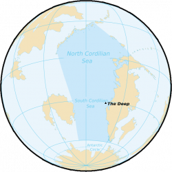
Cordilian Sea (Pacifica)
| Cordilian Sea | |
|---|---|
 | |
| Surface area | 30,630,000 km2 (11,830,000 sq mi) |
| Average depth | 3,260 m (10,700 ft) |
| Max. depth | 6,540 m (21,460 ft) |
| Islands | List of islands |
| Settlements |
|
The Cordilian Sea stretches from the North Pacific Ocean in the north to the Southern Ocean in the south, and washes the shores of Cordilia to the east and the island continent to the west.
It encompasses 30,630,000 km2 (11,830,000 sq mi) in area, and covers about 6% of the total area of Pacifica. The Cordilian Sea splits into two regions with different and independent ocean currents at the equator due to the Coriolis Effect, the North Cordilian Sea and the South Cordilian Sea, this last one taking most of the area of the Cordilian Sea and being the main current in the occidental shore of Cordilia.
Its average depth is around of 3,300 m (10,800 ft). The Deep in the Cordilian Trench, located west of Kosbareland, is the deepest point of the Cordilian Sea.
The Cordilian Sea has some marginal seas within it, including but not limited to the Sea of Frost, the Serevan Sea and the Astro Sea.
Etymology
Since ancient times, the Cordilian Sea has been navigated by diverse civilizations from all places. The name of Cordilian Sea was coined due to being the major sea at the west coasts of the Cordilia continent.