Geography of Rhayna (Pacifica): Difference between revisions
No edit summary |
|||
| Line 282: | Line 282: | ||
| x% = 72.5 | y% = 61 }} | | x% = 72.5 | y% = 61 }} | ||
{{Location mark~ | {{Location mark~ | ||
| width = | | width = 200 | ||
| label = [[Ouróna City (Pacifica)|Ouróna]] | | label = [[Ouróna City (Pacifica)|Ouróna]] | ||
| position = right | | position = right | ||
| Line 289: | Line 289: | ||
| x% = 91.25 | y% = 39.75 }} | | x% = 91.25 | y% = 39.75 }} | ||
}} | }} | ||
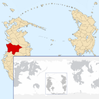
[[File:RhaynaLocation.png|200px|thumb|right|Rhayna's location]] | |||
The [[UPRAN (Pacifica)|UPRAN]] has coastlines on the [[Cordilian Sea (Pacifica)|Cordilian Sea]] and the rivers [[Katharístis (Pacifica)|Katharístis]], [[Mikrós (Pacifica)|Mikrós]], [[Imísy (Pacifica)|Imísy]] and [[Trómeros (Pacifica)|Trómeros]]. Rhayna borders to the north by [[Qaweritoyu (Pacifica)|Qaweritoyu]] and [[Nori Natto (Pacifica)|Nori Natto]], to the east by the [[Míkos Valley (Pacifica)|Míkos Valley]], to the south by the [[Valkyria (Pacifica)|Valkyrian Republic]], [[Hystaiga (Pacifica)|Hystaiga]] and the [[Kosbareland (Pacifica)|Federal Union of Kosbareland]], and to the west by the Cordilian Sea. Rhayna has an area of 931,948 km² (359,827 sq mi) which makes it one of the biggest countries in the South Pacific. | The [[UPRAN (Pacifica)|UPRAN]] has coastlines on the [[Cordilian Sea (Pacifica)|Cordilian Sea]] and the rivers [[Katharístis (Pacifica)|Katharístis]], [[Mikrós (Pacifica)|Mikrós]], [[Imísy (Pacifica)|Imísy]] and [[Trómeros (Pacifica)|Trómeros]]. Rhayna borders to the north by [[Qaweritoyu (Pacifica)|Qaweritoyu]] and [[Nori Natto (Pacifica)|Nori Natto]], to the east by the [[Míkos Valley (Pacifica)|Míkos Valley]], to the south by the [[Valkyria (Pacifica)|Valkyrian Republic]], [[Hystaiga (Pacifica)|Hystaiga]] and the [[Kosbareland (Pacifica)|Federal Union of Kosbareland]], and to the west by the Cordilian Sea. Rhayna has an area of 931,948 km² (359,827 sq mi) which makes it one of the biggest countries in the South Pacific. | ||
Revision as of 21:59, 5 February 2022

The UPRAN has coastlines on the Cordilian Sea and the rivers Katharístis, Mikrós, Imísy and Trómeros. Rhayna borders to the north by Qaweritoyu and Nori Natto, to the east by the Míkos Valley, to the south by the Valkyrian Republic, Hystaiga and the Federal Union of Kosbareland, and to the west by the Cordilian Sea. Rhayna has an area of 931,948 km² (359,827 sq mi) which makes it one of the biggest countries in the South Pacific.
The longest straight-line distance in Rhayna from north to south is 970 km (603 mi), while that from east to west measures 1,370 km (851 mi). Rhayna has roughly 1,416 km (880 mi) of coastline on the Cordilian Sea. It has an Exclusive Economic Zone of 275,408 km² (106,336 sq mi).
Provinces
- Main article: Provinces of Rhayna
UPRAN is divided into 41 provinces, which includes two city-provinces in Rhayna: Pzárya (Pzárya province) and Rouketá (Rouketá province). There are twelve provinces in the Kryó Lake region and twenty-five in the rest of the Rhayna Desert, eight in the Alla-gy Desert and another eight in the Néa-gy state.
Natural regions
The UPRAN is mostly desert. 188,797 km² (72,895 sq mi) - 20.2% (Rhayna: 33,706 km² (13,014 sq mi) - 3.6%, Alla-gy: 19,771 km² (7,634 sq mi) - 2.1%, Néa-gy: 135,320 km² (52,247 sq mi) - 14.5%) - of the total land is cultivated and permanently inhabited. Most of the country lies in the Rhayna and Alla-gy deserts created by the Prostasía and Défteros mountain ranges and Míko valley.
Rhayna's geological history has produced 5 major geographic regions:
- Kryó Lake
- Apoála River
- Tipo and Míkos Valleys
- Rhayna Desert (encompasses Rhayna State)
- Alla-gy Desert (encompasses Alla-gy State)
