Ikoania (Pacifica): Difference between revisions
Jump to navigation
Jump to search
>Tin the free No edit summary |
>Tin the free No edit summary |
||
| Line 59: | Line 59: | ||
|upper_house = <!--Name of governing body's upper house, if given (e.g. "Senate")--> | |upper_house = <!--Name of governing body's upper house, if given (e.g. "Senate")--> | ||
|lower_house = <!--Name of governing body's lower house, if given (e.g. "Chamber of Deputies")--> | |lower_house = <!--Name of governing body's lower house, if given (e.g. "Chamber of Deputies")--> | ||
|sovereignty_type = | |sovereignty_type = Establishment <!--Brief description of country/territory's status ("Independence [from...]", "Autonomous province [of...]", etc)--> | ||
|sovereignty_note = | |sovereignty_note = | ||
|established_event1 = <!--First key event in history of country/territory's status or formation--> | |established_event1 = Independence from [[Ezervulge (Pacifica)|Ezervulge]] <!--First key event in history of country/territory's status or formation--> | ||
|established_date1 = | |established_date1 = 9 August 1885 <!--Date of first key event--> | ||
|established_event2 = <!--Second key event--> | |established_event2 = <!--Second key event--> | ||
|established_date2 = <!--Date of second key event--> | |established_date2 = <!--Date of second key event--> | ||
| Line 70: | Line 70: | ||
|area_rank = | |area_rank = | ||
|area = <!--Major area size (in [[Template:convert]] either km2 or sqmi first)--> | |area = <!--Major area size (in [[Template:convert]] either km2 or sqmi first)--> | ||
|area_km2 = | |area_km2 = 20,379 <!--Major area size (in square km)--> | ||
|area_sq_mi = <!--Area in square mi (requires area_km2)--> | |area_sq_mi = <!--Area in square mi (requires area_km2)--> | ||
|area_footnote = <!--Optional footnote for area--> | |area_footnote = <!--Optional footnote for area--> | ||
|percent_water = | |percent_water = | ||
|area_label = | |area_label = Total <!--Label under "Area" (default is "Total")--> | ||
|area_label2 = <!--Label below area_label (optional)--> | |area_label2 = <!--Label below area_label (optional)--> | ||
|area_data2 = <!--Text after area_label2 (optional)--> | |area_data2 = <!--Text after area_label2 (optional)--> | ||
| Line 80: | Line 80: | ||
|population_estimate_rank = | |population_estimate_rank = | ||
|population_estimate_year = | |population_estimate_year = | ||
|population_census = | |population_census = 2,564,284 | ||
|population_census_year = | |population_census_year = 2020 | ||
|population_density_km2 = | |population_density_km2 = 125.83 | ||
|population_density_sq_mi = | |population_density_sq_mi = | ||
|population_density_rank = | |population_density_rank = | ||
Revision as of 15:43, 9 April 2020
Independent and Sovereign United Federal Union of the Ikoanian Republics of Gralois-Setian and Cartos | |
|---|---|
Motto: "Land of Love and Learning" | |
Anthem: Ikoanian Pride | |
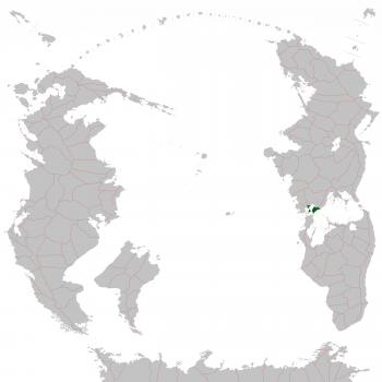
 Location of Ikoania in the South Pacific | |
| Capital | Gralois |
| Official languages | Austral |
| Recognised national languages | Ezervulgish |
| Ethnic groups (2020) | 91.45% Ikoanian 5.32% Ezervulgish 0.49% Sedunnic/Sedunner 2.74% Other/unknown |
| Religion (2020) | 84.31% Non-religious 12.25% Christian 3.44% Other/unknown |
| Demonym(s) | Ikoanian |
| Establishment | |
• Independence from Ezervulge | 9 August 1885 |
| Area | |
• Total | 20,379 km2 (7,868 sq mi) |
| Population | |
• 2020 census | 2,564,284 |
• Density | 125.83/km2 (325.9/sq mi) |
| Currency | Pol (IKP) |
| Time zone | +2 |
| Date format | dd/mm/yyyy CE |
| Driving side | depends on the province |
| Calling code | +26 |
| Internet TLD | .ik |

