Kustannuksan Empire (Pacifica)
Kustannuksan Empire Kustannuksalainen Imperiumi (Kustannan) कुस्तन्नुक्सन साम्राज्य (Vedangari) | |
|---|---|
Motto: "Suuruus seuraa Pohjoistä Tähteä" "महत्त्वं उत्तरतारकस्य अनुसरणं करोति" "Greatness follows the Northern Star" | |
Anthem: "Rule, Kustanna!" Royal anthem: "A golden Star to follow" | |
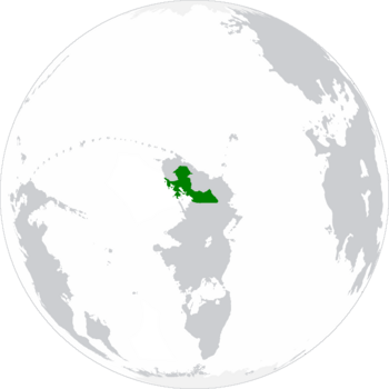
 Territories of the Kustannuksan Empire within northern Bailtem. | |
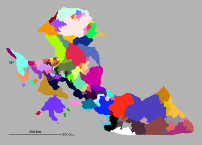
 Imperial Constituent States. | |
| Location | Northern Bailtem. |
| Capital and largest city | Pohjoinen 2°25'N 25°69'E |
| Official languages | Kustannan Vedangari |
| Ethnic groups | Sjöfolk Jasiiradaha Pahaadache Nehirdoğu Nycimbrians Andreians Rhaynans Alla-gyans Nea-gyans Denvari |
| Religion | 48% Atheism 14% Buddhism 9% Bharaism 8% Mesopoism 7% Celthroislic 5% Christianity 5% Islam 4% Azaelism 2% Cult of Axolotls 1% Other |
| Demonym(s) | Kustannuksan/Kustannan |
| Government | Federal Constitutional Monarchy |
• Hallits (Emperor/Empress) | Astrid Madeleine Violetähden II |
• Imperial Chancellor | Emil Otto Michelsen |
• President of the Imperial Senate | Carlo Adamo De Courantis |
• President of the Chamber of Deputies | Mayimuna Kalenga |
• World Forum Ambassador | Evalin Grøndahl |
| Legislature | Imperial Parliament |
| Imperial Senate | |
| Imperial Chamber Of Deputies | |
| Establishment | |
• Kolmen Osavaltion Sopimus | 24 February 1524 CE |
• Golden March | 1552 to 1576 CE |
| Area | |
• Total | 783,286 km2 (302,428 sq mi) |
| Population | |
• 2024 estimate | 163.706.774 |
• Density | 209/km2 (541.3/sq mi) |
| GDP (nominal) | estimate |
• Total | 6,078,000,000,000 |
• Per capita | 37,127 |
| Gini | 21.6 low |
| HDI | 0.961 very high |
| Currency | Tähtirah (TAH) |
| Time zone | UTC+2 (UTC) |
| Date format | dd/mm/yyyy CE - AE |
| Driving side | right |
| Calling code | +150 |
| World Forum Code | KU |
| Internet TLD | .ku |
The Kustannuksan Empire (Kustannan: Kustannuksalainen Imperiumi; Vedangari: कुस्तन्नुक्सन साम्राज्य), alternatively known as Kustannuksa or more rarely as Kustanna, is a sovereign federation of states located in northern Bailtem, bordered by the Dacian Federation, New Altnavia and Amberholde in the north, Andrendia in the east, and the South Pacific Ocean to the west. Kustannuksa's territory is mainly characterized by expansive plains in the north and south-east, and large mountain chains concentrating in the west and center. Kustannuksa has a mostly tropical rainforest climate, although other tropical climates can be found in the south, as well as oceanic and tundra climates which can be found at higher altitudes in the mountain chains. Kustannuksa has a total area of 783,286 km2, and a population of 163 million (as of 2024), which makes it the third largest country by area, and the second most populous country in the South Pacific.
The Empire was founded on 24th of February 1524 with the signing of the Kolmen Osavaltion Sopimus (usually abbreviated as KOS; literally the "Tri-State Agreement"), when the Timandak Confederation, the Kingdom of Kultansuuni and the Merenkul Monarchate created and subsequently joined the new federal state. Even after the formal dissolution of these nations, their previous ruling classes, governments and aristocracies still continued to hold notable power within the new government, as the federal nature of the Empire continued to give them plenty of autonomy: many individuals even became more powerful, as they were appointed by the governments of their states as members of the new Imperial Senate. Most notably the Violetähden Dinasty gained considerable amounts of power in the new government thanks to election of Emine Hürrem Violetähden as Hallits (Empress) of the new Kustannuksan Empire.
Beginning in the 1680s with the end of its isolationism and the establishment of the first imperial colony in what is now known as Chamak, Kustannuksa quickly grew to become one of the South Pacific's most powerful colonial powers: at its peak the empire had colonies, protectorates and ports in western Cordillia, Northern Bailtem and the Rainbow Sea. While many of its possessions were established rather early during the 18th century, Kustannuksa's role as one of the first cradles of the industrial revolution allowed it to create a powerful steam-powered navy that brought unprecedented stability, connection and mercantile power to the flourishing colonial empire. The invention of the telegraph a couple of decades later would only improve the situation even further.
Kustannuksa is a federal constitutional monarchy and a parliamentary democracy. The country is divided into 129 Imperial Constituent States, whose territories match those of the many pre-existing states, cities, lordships and fiefdoms that were annexed by the Empire during the Golden March, or who willingly decided to become constituents. The largest imperial state is Mahasoor, while the most populous one is the Timandak. Kustannuksa's capital and largest city is Pohjoinen, whose metropolitan area has a population of over 16 million people; other major population centers include the cities of Vostolaue, Etelaisi, Terakvis, Kuninlah, Itarannko and Uusimak.
Contemporary Kustannuksa is one of Pacifica's most highly developed nations, having a very well developed welfare system that provides universal health care and tertiary education to its citizens. It ranks very high in quality of life, health and education, and is one of the highest ranking countries in the whole world for the protection of civil liberties, equality, prosperity and human development. The empire is one of the most stable and prosperous countries within the South Pacific and Pacifica at large which, together with religious freedom and LGBT-rights being deeply engrained within its culture, has attracted a lot of attention from migrants and refugees of all backgrounds.
Etymology
Kustannuksa derives from the Old Meruken word "Kustannuksia", which can be best translated as "costs". However, while the etymology of the word is rather certain, it's meaning isn't: currently available records do not state why it was chosen as the name for the new Empire in the KOS, nor do they contain any hints that might lead scholars to formulate any truly meaningful hypothesis. Certain theories suggest that the translation could hint to the KOS being originally envisioned as an economic alliance, but this is fiercely disputed by most.
History
Foundation and Imperial Establishment
Tri-State Agreement
Years of Establishment
Early Expansion
Years of the Golden March
Age of Isolation
Imperial Consolidation
Foreign Traders
End of Isolation
Early Colonial Age
First Alliances
Intercontinental and Oceanic Travels
Establishment of the first Colonies
Conquest of Alcoalitania
Growth of the Trade Networks
Late Colonial Age
Great War
Decolonization
Modern Age
Geography
The Kustannuksan Empire's territories are located in northern Bailtem, between latitudes 5° N and 2° S, and longitudes 19° and 37° E. Kustannuksa's mainland is primarily centered around the eponymous Kustannuksan Gulf and the Korikan Bay, and is mainly delimited by the Sternjesti Cordillera, although a considerable portion extends beyond the mountain range into the large valleys up north, reaching the Ineopbi Mountain Range.
Politics
Government
Administrative Divisions
Law
Foreign Relations
Military
Economy
Tourism
Manufacturing
International Trade
Natural Resources
Demographics
Population
Religion
Language
Education
Health
Largest Cities
Ethnic Groups
Culture
Value system and society
Public holidays
1 January: International New Year's Day
24 February: Imperial Foundation Day
31 December: New Year's Eve

