Moellia (Pacifica)
Moellia
Μοέλλια | |
|---|---|
Aegean geographic region in Cordilia | |
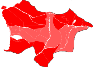
 The Outer Moellia region in red and the Inner Moellia region in light red | |
| Etymology: "Land of Moella" | |
| Coordinates: 33°S 25°W | |
| Area | |
| • Total | 931,948 km2 (359,827 sq mi) |
| Dimensions | |
| • Length | 970 km (600 mi) |
| • Width | 1,370 km (850 mi) |
| Population (2023) | |
| • Total | 44,473,515 |
| • Density | 48/km2 (120/sq mi) |
| Demonym(s) | Rhayno-aegean, Rhaynan, Moellian |
| Time zone | UTC-3, -2 (CCT) |
| • Summer (DST) | UTC-2, -1 (CCT) |
Moellia is a historical, geographic and ethnic region in Central Cordilia encompassing the entirety of the present-day United Provinces of Rhayna.
First used by Rhayno-aegeans from Rhayna, Alla-gy and Nea-gy independently one from another around 3,000 BCE, the term includes all territories enclosed between the Cordilian Sea, the Prostasia Range, the Defteros Range and the Eastern Cordilian Desert. In these territories, aegeans from the 30,000 BCE migration routes first settled along the coasts, lakes, and rivers of the region.
The area is home to almost only aegeans, with only mixes of populations due to internal migration between Rhaynans, Alla-gyans and Nea-gyans. There's also a small minority of assimilated Pastens in the Outer Moellia area of Nea-gy, more specifically in the Tipo Valley.
Moellia is currently the biggest region of Aegean ethnic and speakers. Since the first definitions of this territory, turmoil has been present during most of its history until just recently in 1965 with the unification of the Aegean republics after the Rhaynan Civil War.
Boundaries
Moellia is now most often associated with the three Rhaynan states of Rhayna, Alla-gy and Nea-gy, and with the nation of the United Provinces of Rhayna. Usually it is agreed that the frontiers of Moellia end with the frontiers of UPRAN. Furthermore, the area can be divided into three territories by the Prostasia and Defteros Ranges: Rhaynan Moellia, Alla-gyan Moellia and Nea-gyan Moellia. Added to this, it can also be divided into four regions: North Rhaynan Outer Moellia, North Nea-gyan Outer Moellia, South Allo-Rhaynan Outer Moellia, and Inner Moellia.
North Rhaynan Outer Moellia
North Rhaynan Outer Moellia is defined as the northern region populated by Rhayno-aegeans between 30,000 BCE and 21,000 BCE. This is known to have been done through the North Salyrasitic Routes, Atzalo-Kaly Thean Route, the Imisy Delta Route and the Lariteian-Imisian Route. The area extends latitudinally from the frontier with Qaweritoyu to the Imisy, and extends longitudinally from Kaly Thea to the Prostasia Range. During ancient history, it saw rather soon the apparition of organized states, focused on the expansion towards the south along the Katharistis and through the North Rhaynan Desert.
This region has been populated by various Aegean cultures and civilizations, and to this day it conserves various traditions, cultural activities and beliefs practised since the arrival of humans to the region. Regions as the Ryzi Marshes, Kaly Thea or the Katharistis riverbed hold various historical locations like temples, old cities, ruins and megalithic structures.
North Nea-gyan Outer Moellia
North Nea-gyan Outer Moellia is a region located in the northern part of Nea-gy, inhabited by Rhayno-aegeans since 29,000-25,000 BCE. Archaeological finds suggests that moderns humans arrived to the area through the Tipo Valley Routes. The region stretches from the border with the Republic of Past to the Mikros and Mesaia, and from the Defteros Range to the surroundings of Pantoupoli. In ancient times, the area was home to several organized states that expanded eastwards along the Mikros, through the Tipo Valley and towards the modern day Pantoupoli.
The North Nea-gyan Outer Moellia region is dotted with many historically significant locations, including ancient temples, ruins, megaliths, and old cities. Some of the most notable locations in the region include the extensive savannah of the Tipo Valley, and the breathtaking landscapes of the bold Defteros Range and its ancient carvings of ancient and current Nea-gyan motifs.
South Allo-Rhaynan Outer Moellia
South Allo-Rhaynan Outer Moellia can be defined as the region situated in the southern part of Rhayna and Alla-gy, inhabited by the Rhayno-aegeans between 23,000 BCE and 20,000 BCE. Anthropological settlements suggest that humans first arrived in the area through the Rouketa Route and the Oclian Route into Rhayna, and through the Late Keponian Routes into Alla-gy. The region stretches from Lake Kryo and the Erchomos to the frontier with the Federal Union of Kosbareland and Hystaiga, and from the Cordilian Sea to the Defteros Range, going through the Prostasia Range. Although the territory is split in two by a geographic barrier, the group of Rhayno-aegeans that populated the area separated pretty late into Rhayna and Alla-gy, so they shared a multitude of commons things between the two, unlike the rest of Moellia. To this day, after 22,000 years, the populations of the south of Rhayna and Alla-gy share lots of characteristics.
The South Allo-Rhaynan Outer Moellia region is filled with numerous significant historical sites, thousands of generations in age. The region is home to the vast South Rhaynan Desert, the Keponian Valley, the shores of Lake Kryo and the Cordilian Sea, the fast waters of the Tromeros, the broad waters of the Apoala; the widest river in UPRAN, and the huge natural walls of the Prostasia Range and the Defteros Range.
Inner Moellia
Inner Moellia is considered as all the regions populated by humans between 25,000 BCE and 15,000 BCE. This is thought to have been made through the Pantynese Coast Route and the Trans-hamahonian Route in Rhayna; the Prostasian Base Routes and the Mantilian Pass Route in Alla-gy; and the Defteran Base Route and the Caroro-Boinonian Route in Nea-gy, although the number of anthropological remains in this region have been found to be noticeably scarce in comparison with the Outer Moellian regions. Few organized states were founded in this region besides the ones in Lake Kryo and a few small city states.
Still, various cultural and natural wonders can be found in Inner Moellia. The plethora of locations in this region ranges from lakes to rivers, savannahs, deserts, mountains, valleys, sea, and other natural biomes. It's the biggest region by far, and it stretches from one side of UPRAN to the other, and from the most northern point in Alla-gy to the most southern point in Nea-gy.
Geography and climate
