Pre-Axolian States (Pacifica)
Jump to navigation
Jump to search


Pre-Axolian States is a definition used by historians to define all the Nations that controlled territories in Apennia, now all part of Andrendia.
List of States by Era[1]

Ancient Era (Circa 10.000 BC-686)[2]
- Vulcanbonian Kingdom
- Axoland Kingdom
- Republic of Arancio
Middle Era (686-1387)
- Vulcanbonian State
- Axoli Republic
- Confederation of the Magazo
- Republic of Arancio
- Republic of the Tirriatico
- Cilentranean Kingdom
- Confederation of the Alps
- Great Duchy of Picentania
Early Axolian Era (1387-1496)
- Axolian Empire
- Vulcanbonian State
- Free State of the Magazo
- Republic of Arancio
- Tirriatican Empire
- Cilentranean Kingdom
Axolian Era (1496-1577)
- Axolian Empire
- Vulcanbonian Federation
- Republic of Arancio
- Tirriatican Empire
Early Andreian Era (1577-1798)
- Andrendia
- Republic of Arancio
Andreian Era - New Andreian Era (1798-Present Day)
- Andrendia
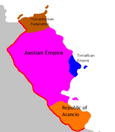
Map of the Axolian Era 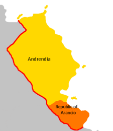
Map of the Early Andreian Era


Notes
