UPRAN (Pacifica)
United Provinces of Rhayna, Alla-gy and Néa-gy Ηνωμένες Επαρχίες του Ράινα, Αλλα-Γη και Νέα-Γη | |
|---|---|
Motto: Long Life Us All Mάκρος ζωή Μας Ολοι | |
Anthem: Path for All Μονοπάτι για Óλους | |
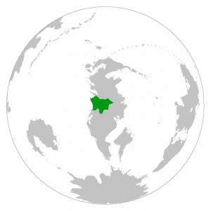
 Location of Rhayna in the South Pacific | |
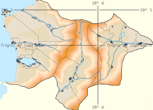
 Closeup of Rhayna | |
| Capital | Pzárya |
| Largest city | Rouketá |
| Official languages | Aegean, Austral |
| Recognised national languages | Aegean, Austral |
| Sign languages | Aegean Sign Language Νοηματική Γλώσσα Αιγαίο (ΝΓA/NGA) Austral Sign Language (ASL) |
| Ethnic groups (2020 census) | 18.67% Rhaynans 7.82% Alla-gyans 73.43% Néa-gyans 0.08% Romordians |
| Religion (2020 census) | 51.0% Religious 47.1% No religion 1.9% Unanswered |
| Demonym(s) | Rhaynan |
| Government | Federal democratic parliamentary constitutional republic |
• Prytanis | Boutros Georgiou |
| Gisella de Luca | |
| Aria Iliadis | |
| Fabiano Marchesi | |
| Astra Panou | |
| Legislature | Genikés Kámeres |
| UPRAN Congress | |
| Rhayna's Chamber of Deputies | |
| Federal independent republic | |
| 3145-520 BC | |
| 520-327 BC | |
| 327-25 BC | |
| 25 BC-646 AD | |
| 646-709 AD | |
| 709-843 | |
| 843-1085 | |
| 1078 | |
| 1085 | |
| 1085-1512 | |
| 1512-1922 | |
| 30 September, 1923-1953 | |
| 7 July, 1953-1965 | |
• UPRAN Republic | 6 May, 1965-2021 |
| Area | |
• Total | 931,948 km2 (359,827 sq mi) |
| Population | |
• 2021 estimate | 57,825,790 |
• 2020 census | 51,178,065 |
• Density | 54.95/km2 (142.3/sq mi) |
| GDP (PPP) | 2020 estimate |
• Total | 2.37 trillion |
• Per capita | $46,313.25 |
| GDP (nominal) | 2020 estimate |
• Total | 1.77 trillion |
• Per capita | $34,564.30 |
| Currency | Sigma (SIG) |
| Time zone | UTC-3, -2 (CCT) |
• Summer (DST) | UTC-2, -1 (CCT) |
| Date format | dd/mm/yyyy CE |
| Driving side | right |
| Calling code | +65 |
| World Forum Code | RHA |
| Internet TLD | .rha, .ραι |
Rhayna (Aegean: Ράινα, Aegean pronunciation: [ráina]), United Provinces of Rhayna (Aegean: Ηνωμένες Επαρχίες του Ράινα, Aegean pronunciation: [inoménes eparchíes tou ráina]) or United Provinces of Rhayna, Alla-gy and Néa-gy (Aegean: Ηνωμένες Επαρχίες του Ράινα, Αλλα-Γη και Νέα-Γη, Aegean pronunciation: [inoménes eparchíes tou ráina alla gi kai néa gi]) is a big sized country located in the South Pacific and located in the middle of Cordilia, bordered by Qaweritoyu to the north; Past at the east; the Valkyrian Republic, Hystaiga and the Federal Union of Kosbareland to the south; and the Cordilian Sea to the west.
Composed of three main parts, Rhayna's territory splits into three states; Rhayna, Alla-gy and Néa-gy, which, in order, enter the interior of the continent from the west to the east. It covers an area of 931,948 square kilometers (359,827 sq mi), and it has mainly an arid climate, except to the east in Neá-gy. Here there is a humid subtropical climate, and on the banks of large rivers such as the Trómeros or Apóala, where it is usually cultivated after its annual floods. The capital is Pzárya, located in Rhayna at the mouth of the Imísy, and the largest city is Rouketá, with Pzárya just behind.
Rhayna was the cradle for the ancient civilization that was born on the shores of Trómeros and its lake Kryó, which between 520 BC and 25 AD expanded to the territory behind the mountain ranges of Prostasía and Défteros. During the conquest, natives from the north of Alla-gy attacked back, which led to the Deodian dictatorship in 646 BC in order to unify the three territories and maintain control in Alla-gy.
At the beginning of the 8th century the Deodian dictatorship ended and Rhayna's 1st Great Republic was created. This did not last long, and after a century it was replaced by a monarchy started in Rhayna. This triggered the creation of independent kingdoms in Alla-gy and Néa-gy, which caused Rhayna's Great Dissolve and dissolution of the territory. In 1085, the Union Revolution broke out, leading to the execution of the kings of Rhayna, Alla-gy and Néa-gy, the union of the three territories and the creation of Rhayna's 2nd Great Republic, which lasted until the early 16th century, more than 400 years.
In 1512 the expansion of the Union was necessary, so the Great Rhaynan Kingdom was established, whose function was to direct population campaigns in the deserts of Rhayna and Alla-gy, through the establishment of irrigation and villages in the vicinity of Prostasía and Défteros. This ended in warlike tensions with Hystaiga in the Apóala War, which resulted in Rhayna's 3rd Great Republic and the almost total population of the Rhaynan and Alla-gyan deserts in the early 20th century.
Thanks to the creation of the railroad, full communication was achieved between the previously almost totally isolated regions of Rhayna, which allowed a greater stability of the Union and avoid an event like that of Rhayna's Great Dissolve. In the middle of the 20th century, a coup against the government of the 3rd Republic was committed by the military, lead by Elián Vasileiou, and a personalist dictatorship was established. This dictatorship only lasted 12 years, thanks to the troops of Rhayna and Néa-gy, Elián was captured and executed for crimes of mass genocide and war crimes against minorities populations of Alla-gy. In 1965 the UPRAN Republic was established, the Union's Constitution was written and stability has been maintained to this day.
On the world stage, Rhayna didn't participate for much of the Great War, thought at the end of the war and the Eliánic dictatorship it joined the winning allied side as the UPRAN.
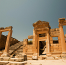
Today Rhayna is an independent democratic constitutional republic led by the prytanis and viceprytanis. It is a developed nation that offers various welfare services. Among its raw materials are hydroelectric and solar energy, oil, metals and beef, in addition to offering tourism services such as long cruise trips on the Trómeros or the Imísy or visits to museums with various relics of Ancient Rhayna. The different regions of Rhayna have partial autonomy in their decisions except in the army, welfare services, vital services and others, which are controlled by the central government.
Etymology
Rhayna's name has been distorted over the years, although in Aegean it can still be translated as "rain", which is strange considering the main climate. Theories hold that civilization grew on the shores of lake Kryó, which would release large amounts of moisture into the air that would fall as rain, which would explain in a certain part the ironic name.
Meanwhile, the name of Spyssína has been severely distorted by Italikí influence. Even so, the name has been deciphered thanks to writings found in some ruins of Rouketá, which spoke about the etymology of the name. The word Spyssína /Spy-ssí-na/ is translated to Ancient Aegean as Σπισσίνα /Σπι-σσί-να/, Spy-s comes from Spy-tis (which means "house"), where the syllable "tis" was shortened to a single "s", and Sína /S-ína/ comes from the name of the goddess of Apóala of Italikís, thus meaning "House of Sína".
On the contrary, the name of Itiskír has been so distorted that it could not be deciphered exactly, although it is believed that it may mean something similar to "the house" or "the temple" of "Kír", goddess of the river Mesaia, but this knowledge could change in future research.
History
- Main article: History of Rhayna
Prehistory and early history

The earliest evidence of the presence of human ancestors in the Rhaynan Desert, dated to 30,000 BC, is to be found in the Soria Remains, in the Rhaynan province of Rouketá. All three stages of the Stone Age (Paleolithic, Mesolithic, and Neolithic) are represented in Rhayna, for example in the Ósta Cave, in Mt. Atzáli. Neolithic settlements in Rhayna, dating from the 10th millennium BC, are some of the oldest in Cordilia, as Rhayna lies mid-way on the migration route of a specific population of aegeans through Central and South Cordilia.

Following the end of the Rhaynan Neolithic period and the Lost Age in 3,200 BC, a slow transition period between the stone economy to the bronze economy produced during the end of the 4th Millennium BC including the apparition of Corenian and Odymnan cultures in the mouth of the Imísy; Godosian Culture in the Delta of the Trómeros; Crotissan, Kamareucian and Phocanean cultures in the Kalythéan island; and Hyeleran, Aegenaean, Mylyrian, Lariteian, Sicatrean, Nysatrean and Salenian cultures around Kryós, with the first large buildings (Sitonion Palace) being built by each city state and their colonies until the start of the 1st Millennium BC, when the majority of city states that were once separated were united by Timoleon VI.
In Rhayna, the Godosian, Corenian, and Kalythéan city states are considered as the main theaters of developments of the Rhaynan civilization. These civilizations possessed writing, all of them sharing local variations of Aegean script. The Godosians gradually absorbed the Salenian. Still with this civilizations being the main powers of the military and economic landscape of the water shores of Rhayna, they fell and raised back many times until the unification of the majority of this, resulting in many of those writings dating before the 1100 BC being lost or having oral reinterpretations of them.
Geography
- Main article: Geography of Rhayna
Rhayna lies primarily between latitudes -30º and -19ºN, and longitudes -39.5º and -25ºE. At 931,948 square kilometres (359,827 sq mi), it's one of the biggest countries in the South Pacific. Due to the extreme aridity of Rhayna's and Alla-gy's climate, population centres are concentrated along the narrow rivers valleys, deltas and Néa-gy.
Rhayna borders to the north by Qaweritoyu and Nori Natto, to the east by Past, to the south by the Valkyrian Republic, Hystaiga and the Federal Union of Kosbareland, and to the west by the Cordilian Sea.
Apart from the valleys of the major rivers and Néa-gy, the majority of Rhayna's landscape is desert, with a few oases scattered about. Winds create prolific sand dunes that peak at more than 25 metres (82 ft) high in Rhayna, while in Alla-gy dunes barely reach the 5 meters due to the surrounding mountains.

