Administrative divisions of Sedunn (Pacifica): Difference between revisions
>Qwert No edit summary |
No edit summary Tag: 2017 source edit |
||
| (20 intermediate revisions by 2 users not shown) | |||
| Line 1: | Line 1: | ||
Since the administrative reform of 2014 [[Sedunn (Pacifica)|Sedunn]] has three levels of administrative divisions. The territory is divided into | Since the administrative reform of 2014 [[Sedunn (Pacifica)|Sedunn]] has three levels of administrative divisions. The territory is divided into sixteen regions ([[Sedunnic language (Pacifica)|Sedunnic]]: ''dolē''), which are further divided into 416 municipalities (''tavvasa'lē'') and 33811 districts (''ovutlē''). The regions are self-governing local authorities responsible for providing advanced public health care, public transportation and regional development. The municipalities have local self-governing authority and are the main welfare providers. They also provide emergency services, public social services, sanitation and urban and rural planning. The purpose of the districts is population registration, including civil registration of births, marriages, civil partnerships and deaths, and for the collation of census information. | ||
<!--Furthermore, all regions belong to one of the six so-called authority coordination regions (Sedunnic: ''stoveaffulsaflē'' (SES)). Various authorities such as those for military and civilian defence or energy use these to coordinate and delegate planning and daily work.--> | |||
There are eleven historical counties (Sedunnic: ''haenlē'') that still are important in culture. The counties are still recognised officially, but since the latest administrative reform all real duties were assumed by the new regions which were designed to have a more equal population distribution. Culturally, Sedunn is also divided into Beilltemm-Sedunn (Bailtem-Sedunn) for the lands located in [[South Pacific (Pacifica)#Bailtem|Bailtem]] and the overseas territory [[Remetull Islands (Pacifica)|Remetull Islands]] in the [[South Pacific Ocean (Pacifica)|South Pacific Ocean]] <!--[[Vastraenn (Pacifica)|Vastraenn]] in [[South Pacific (Pacifica)#Keyli|Keyli]]-->. Sometimes Beiltemm-Sedunn is subdivided into Ankjytann (Cisjytann)and Akjytann (Transjytann), dividing the mainland along the watershed line in the Jytann Mountain Range. | |||
== Regions== | |||
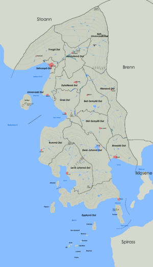
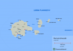
The region is the top-level administrative level of Sedunnic territory. The regions were created in 2014 in attempt to achieve a division with more equal population numbers than the old counties had. For example, the smallest county Deriess had a population of 175,000 while the most populous, Servelann, had almost nine million inhabitants. <!--Excluding Vastraenn,-->The region with the lowest population is now Remetull Islands with almost 1.7 million inhabitants, while the most populous one is Setrusop (the capital region) with a population of almost 6.5 million. The borders of the regions are based on the old counties to large degree. There are sixteen regions. | |||
The regions are self-governing local authorities responsible for providing advanced public health care, public transportation and regional development. The seat of the region government is either in the largest city or the most central city. | |||
The | |||
[[File:Regions of Bailtem Sedunn.png|thumb|300px|regions in Bailtem-Sedunn and their capitals]] | |||
[[File:Remetull cities.png|thumb|300px|Remetull Islands region]] | |||
[[File: | {| class="wikitable sortable" style="text-align: center;" ;" | ||
{| class="wikitable sortable" | |||
!Coat of arms | !Coat of arms | ||
!Name | !Name | ||
!Capital | ![[List of cities in Sedunn (Pacifica)|Capital]] | ||
!Area (km<sup>2</sup>) | !Area (km<sup>2</sup>) | ||
!Population (2019) | !Population (2019) | ||
|- | |- | ||
|[[File:Annhotem province coat of arms.png|20px]] | |[[File:Annhotem province coat of arms.png|20px]] | ||
|Annhotem | |Annhotem | ||
|Lomared | |Lomared | ||
| | |5,653 | ||
| | |2,179,541 | ||
|- | |- | ||
|[[File:Bell-Limmvasd province coat of arms.png|20px]] | |[[File:Bell-Limmvasd province coat of arms.png|20px]] | ||
|Bell-Limmvasd | |Bell-Limmvasd | ||
|Arlied | |Arlied | ||
| | |18,851 | ||
| | |2,577,126 | ||
|- | |- | ||
|[[File:Bell-Semyll province coat of arms.png|20px]] | |[[File:Bell-Semyll province coat of arms.png|20px]] | ||
|Bell-Semyll | |Bell-Semyll | ||
|Eressivv | |Eressivv | ||
| | |7,208 | ||
| | |2,456,612 | ||
|- | |||
||[[File:Dere-Jytann region CoA.png|20px]] | |||
|Derē-Jytann | |||
|Urmoll | |||
|12,388 | |||
|3,756,167 | |||
|- | |- | ||
|[[File:Dybdfess province coat of arms.png|20px]] | |[[File:Dybdfess province coat of arms.png|20px]] | ||
|Dybdfess | |Dybdfess | ||
|Goends | |Goends | ||
| | |4,869 | ||
| | |3,834,373 | ||
|- | |- | ||
|[[File:Ekredd province coat of arms.png|20px]] | |[[File:Ekredd province coat of arms.png|20px]] | ||
|Ekredd | |Ekredd | ||
|Flered | |Flered | ||
| | |5,575 | ||
| | |3,939,071 | ||
|- | |||
|[[File:Epptryn region CoA.png|20px]] | |||
|Epptryn | |||
|Durivv | |||
|11,033 | |||
|3,223,664 | |||
|- | |- | ||
|[[File:Gra province coat of arms.png|20px]] | |[[File:Gra province coat of arms.png|20px]] | ||
|Grā | |Grā | ||
|Tavenst | |Tavenst | ||
| | |6,007 | ||
| | |2,125,736 | ||
|- | |- | ||
|[[File:Hierann province coat of arms.png|20px]] | |[[File:Hierann province coat of arms.png|20px]] | ||
|Hierann | |Hierann | ||
|Kodull | |Kodull | ||
| | |11,025 | ||
| | |2,668,623 | ||
|- | |||
||[[File:Leve-Jytann region CoA.png|20px]] | |||
|Levē-Jytann | |||
|Troma | |||
|11,414 | |||
|2,694,531 | |||
|- | |- | ||
|[[File:Limravad province coat of arms.png|20px]] | |[[File:Limravad province coat of arms.png|20px]] | ||
|Limravad | |Limravad | ||
|Ullenst | |Ullenst | ||
| | |4,843 | ||
|1, | |2,116,940 | ||
|- | |||
|[[File:Remetullessle_province_coat_of_arms.png|20px]] | |||
|Remetullnesslē | |||
|Tarvem | |||
|9,991 | |||
|1,665,248 | |||
|- | |||
||[[File:Rumm region CoA.png|20px]] | |||
|Rumm | |||
|Ilosred | |||
|11,033 | |||
|2,740,030 | |||
|- | |- | ||
|[[File:Setrusop province coat of arms.png|20px]] | |[[File:Setrusop province coat of arms.png|20px]] | ||
|Setrusop | |Setrusop | ||
|Grovne | |[[Grovne (Pacifica)|Grovne]] | ||
| | |1,031 | ||
| | |6,523,984 | ||
|- | |- | ||
|[[File:Ske-Semyll province coat of arms.png|20px]] | |[[File:Ske-Semyll province coat of arms.png|20px]] | ||
|Skē-Semyll | |Skē-Semyll | ||
|Savvered | |Savvered | ||
| | |7,367 | ||
| | |2,117,198 | ||
|- | <!--|- | ||
|[[File:Vastraenn province coat of arms.png|20px]] | |[[File:Vastraenn province coat of arms.png|20px]] | ||
|Vastraenn | |Vastraenn | ||
|Sraved | |Sraved | ||
| | |26,994 | ||
|76,000 | |76,000--> | ||
|- | |- | ||
|[[File:Yveg province coat of arms.png|20px]] | |[[File:Yveg province coat of arms.png|20px]] | ||
|Yveg | |Yveg | ||
| | |Mukshodd | ||
|11,073 | |||
|2,002,540 | |||
|- class="sortbottom static-row-header" style="border-top: 2px solid grey;" | |||
|{{flag|Sedunn}} | |||
| | |||
| | | | ||
| | |136,628 | ||
| | |46,621,383 | ||
|} | |} | ||
== Municipalities == | ==Municipalities== | ||
[[File:Municipalities of Bailtem-Sedunn.png|thumb|300px|Municipalities in Bailtem-Sedunn and their capitals]] | [[File:Municipalities of Bailtem-Sedunn.png|thumb|300px|Municipalities in Bailtem-Sedunn and their capitals]] | ||
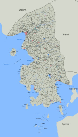
Sedunn is divided into | Sedunn is divided into 319 self-governing municipalities, of which 22 are located on the Remetull Islands. The municipalities generally consist of one [[List of cities in Sedunn (Pacifica)|city]] or town and adjacent villages and land. The largest settlement in the municipality is generally the seat of the municipal government and the municipality is also named after it. The municipalities are the main welfare providers and also provide emergency services, public social services, sanitation and urban and rural planning. | ||
Vastraenn is | ==Districts== | ||
The lowest administrative level of Sedunn is the district. The purpose of the districts is population registration, including civil registration of births, marriages, civil partnerships and deaths, and for the collation of census information. | |||
<!-- == Authority coordination regions === | |||
[[File:SES of Bailtem-Sedunn.png|thumb|left|300px|Authority coordination regions in Bailtem-Sedunn and their centres]] | |||
The various authorities, local governments and public utilities (including those for military and civilian defence or energy) are encouraged, or in applicable cases, mandated to coordinate and delegate planning, daily work and resources in the so-called authority coordination regions. There are five regions in Bailtem-Sedunn consisting of two to three regions. The Remetull Islands are while Vastraenn is its a region of their own. The regions are expected to maintain a level of self-sufficiency in case of disasters or war.--> | |||
==Counties== | |||
[[File:Counties of Bailtem-Sedunn.png|thumb|300px|Counties in Cisjytann]] | |||
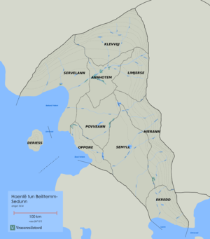
The highest administrative level of Sedunn was the county until the 2014 reform. The counties still exist, but have no official function. There are eleven counties, and they have remained relatively unchanged from their creation in the late 15th century. The responsibilities of the counties were transferred to the regions and authority coordination regions, but they still hold a cultural significance and represent separate dialect continua. | |||
==See also== | |||
*[[List of cities in Sedunn (Pacifica)|List of cities in Sedunn]] | |||
*[[Geography of Sedunn (Pacifica)|Geography of Sedunn]] | |||
*[[Sedunnic toponymy (Pacifica)|Sedunnic toponymy]] | |||
[[category:Sedunn (Pacifica)]] | |||
Latest revision as of 19:15, 26 July 2023
Since the administrative reform of 2014 Sedunn has three levels of administrative divisions. The territory is divided into sixteen regions (Sedunnic: dolē), which are further divided into 416 municipalities (tavvasa'lē) and 33811 districts (ovutlē). The regions are self-governing local authorities responsible for providing advanced public health care, public transportation and regional development. The municipalities have local self-governing authority and are the main welfare providers. They also provide emergency services, public social services, sanitation and urban and rural planning. The purpose of the districts is population registration, including civil registration of births, marriages, civil partnerships and deaths, and for the collation of census information.
There are eleven historical counties (Sedunnic: haenlē) that still are important in culture. The counties are still recognised officially, but since the latest administrative reform all real duties were assumed by the new regions which were designed to have a more equal population distribution. Culturally, Sedunn is also divided into Beilltemm-Sedunn (Bailtem-Sedunn) for the lands located in Bailtem and the overseas territory Remetull Islands in the South Pacific Ocean . Sometimes Beiltemm-Sedunn is subdivided into Ankjytann (Cisjytann)and Akjytann (Transjytann), dividing the mainland along the watershed line in the Jytann Mountain Range.
Regions
The region is the top-level administrative level of Sedunnic territory. The regions were created in 2014 in attempt to achieve a division with more equal population numbers than the old counties had. For example, the smallest county Deriess had a population of 175,000 while the most populous, Servelann, had almost nine million inhabitants. The region with the lowest population is now Remetull Islands with almost 1.7 million inhabitants, while the most populous one is Setrusop (the capital region) with a population of almost 6.5 million. The borders of the regions are based on the old counties to large degree. There are sixteen regions.
The regions are self-governing local authorities responsible for providing advanced public health care, public transportation and regional development. The seat of the region government is either in the largest city or the most central city.


| Coat of arms | Name | Capital | Area (km2) | Population (2019) |
|---|---|---|---|---|
| Annhotem | Lomared | 5,653 | 2,179,541 | |
| Bell-Limmvasd | Arlied | 18,851 | 2,577,126 | |
| Bell-Semyll | Eressivv | 7,208 | 2,456,612 | |
| Derē-Jytann | Urmoll | 12,388 | 3,756,167 | |
| Dybdfess | Goends | 4,869 | 3,834,373 | |
| Ekredd | Flered | 5,575 | 3,939,071 | |
| Epptryn | Durivv | 11,033 | 3,223,664 | |
| Grā | Tavenst | 6,007 | 2,125,736 | |
| Hierann | Kodull | 11,025 | 2,668,623 | |
| Levē-Jytann | Troma | 11,414 | 2,694,531 | |
| Limravad | Ullenst | 4,843 | 2,116,940 | |
| Remetullnesslē | Tarvem | 9,991 | 1,665,248 | |
| Rumm | Ilosred | 11,033 | 2,740,030 | |
| Setrusop | Grovne | 1,031 | 6,523,984 | |
| Skē-Semyll | Savvered | 7,367 | 2,117,198 | |
| Yveg | Mukshodd | 11,073 | 2,002,540 | |
| 136,628 | 46,621,383 |
Municipalities

Sedunn is divided into 319 self-governing municipalities, of which 22 are located on the Remetull Islands. The municipalities generally consist of one city or town and adjacent villages and land. The largest settlement in the municipality is generally the seat of the municipal government and the municipality is also named after it. The municipalities are the main welfare providers and also provide emergency services, public social services, sanitation and urban and rural planning.
Districts
The lowest administrative level of Sedunn is the district. The purpose of the districts is population registration, including civil registration of births, marriages, civil partnerships and deaths, and for the collation of census information.
Counties

The highest administrative level of Sedunn was the county until the 2014 reform. The counties still exist, but have no official function. There are eleven counties, and they have remained relatively unchanged from their creation in the late 15th century. The responsibilities of the counties were transferred to the regions and authority coordination regions, but they still hold a cultural significance and represent separate dialect continua.