Cordilian Sea (Pacifica): Difference between revisions
(→Nuclear Waste: (new regime developments)) Tag: 2017 source edit |
No edit summary |
||
| (12 intermediate revisions by 6 users not shown) | |||
| Line 19: | Line 19: | ||
* {{flag|Hystaiga}} | * {{flag|Hystaiga}} | ||
** Karelia | ** Karelia | ||
* {{flag|Pyhdon}} | |||
** Aal-Adhan Cherkhyre, Malheureuesement, Rasseur, Astro, Sardin, Bharian, Sinirac, Sandilands, Suleje | |||
* {{flag|Ryccia}} | * {{flag|Ryccia}} | ||
| Line 27: | Line 30: | ||
* {{flag|UPRAN}} | * {{flag|UPRAN}} | ||
** Ploio, | ** Parathyro, Ploio, Porta, Xeno, Pzarya, Thymiama, Tyri, Rouketa, | ||
| Line 38: | Line 40: | ||
}} | }} | ||
The Cordilian Sea stretches from the North Pacific Ocean in the north to the Southern Ocean in the south, and washes the shores of Cordilia to the east and the island continent to the west. | The '''Cordilian Sea''' stretches from the North Pacific Ocean in the north to the Southern Ocean in the south, and washes the shores of Cordilia to the east and the island continent to the west. | ||
It encompasses {{convert|30630000|km2|abbr=on}} in area, and covers about 6% of the total area of Pacifica. The Cordilian Sea splits into two regions with different and independent ocean currents at the equator due to the Coriolis Effect. It splits into the North Cordilian Sea and the South Cordilian Sea, this last one taking most of the area of the Cordilian Sea and being the main current in the occidental shore of Cordilia. | It encompasses {{convert|30630000|km2|abbr=on}} in area, and covers about 6% of the total area of Pacifica. The Cordilian Sea splits into two regions with different and independent ocean currents at the equator due to the Coriolis Effect. It splits into the North Cordilian Sea and the South Cordilian Sea, this last one taking most of the area of the Cordilian Sea and being the main current in the occidental shore of Cordilia. | ||
| Line 47: | Line 49: | ||
== Etymology == | == Etymology == | ||
Since ancient times, the Cordilian Sea has been navigated by diverse civilizations from all places. The name of Cordilian Sea was coined due to being the major sea at the west coasts of the | Since ancient times, the Cordilian Sea has been navigated by diverse civilizations from all places. The name of Cordilian Sea was coined due to being the major sea at the west coasts of the Cordilian continent. | ||
== Geography == | == Geography == | ||
| Line 62: | Line 64: | ||
* {{flag|Eflad}} | * {{flag|Eflad}} | ||
* {{flag|Frost Empire}} | * {{flag|Frost Empire}} | ||
* {{flag| | * {{flag|Gianatla}} | ||
* {{flag|Holy Free}} | * {{flag|Holy Free}} | ||
* {{flag|Hystaiga}} | * {{flag|Hystaiga}} | ||
| Line 72: | Line 74: | ||
* {{flag|UPRAN}} | * {{flag|UPRAN}} | ||
* {{flag|Valora}} | * {{flag|Valora}} | ||
* {{ | * {{Flag|Pyhdon|Bullet Point}}{{div col end}} | ||
{{div col end}} | |||
===Landmasses and islands=== | ===Landmasses and islands=== | ||
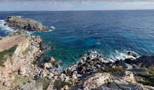
[[File:Kaly Theá Coast.png|thumb|300x300px|Picture from Kaly | [[File:Kaly Theá Coast.png|thumb|300x300px|Picture from Kaly Thea's coast of the Cordilian Sea.]] | ||
All the islands in the Cordilian Sea are islands that limit it or continental islands. There are about 85 islands in the Cordilian Sea. | All the islands in the Cordilian Sea are islands that limit it or continental islands. There are about 85 islands in the Cordilian Sea. | ||
Islands in the Cordilian Sea are of four basic types: continental islands and high islands. Continental islands lie outside the andesite line and include Kaly | Islands in the Cordilian Sea are of four basic types: continental islands and high islands. Continental islands lie outside the andesite line and include Kaly Thea, the many islands of Techganet, the island chains of Kosbareland and Qaweritoyu, and others. All of these islands are structurally associated with nearby continents. High islands are of volcanic origin, and many contain active volcanoes. Among these are Snolland, Bruuma, and others. | ||
==Water characteristics== | ==Water characteristics== | ||
[[File:Viliakmon-beach.jpg|thumb|300x300px|Sunrise | [[File:Viliakmon-beach.jpg|thumb|300x300px|Sunrise over the Cordilian Sea.|left]] | ||
The volume of the Cordilian Sea has been estimated at some {{convert|200000000|km3|abbr=off}}. Surface water temperatures in the Cordilian Sea can vary from {{convert|10|C|abbr=on}}, in the southern borders with the Antarctic Ocean, to about {{convert|30|C|abbr=on}} near the equator. Salinity also varies latitudinally, reaching a maximum of 37 parts per thousand in the southern area. The water near the equator, which can have a salinity as low as 34 parts per thousand, is less salty than that found in the mid-latitudes because of abundant equatorial precipitation throughout the year. The lowest counts of less than 32 parts per thousand are found in the far south, as less evaporation of seawater takes place in these frigid areas. The motion of Cordilian waters is generally clockwise in the Northern Hemisphere and counter-clockwise in the Southern Hemisphere. | The volume of the Cordilian Sea has been estimated at some {{convert|200000000|km3|abbr=off}}. Surface water temperatures in the Cordilian Sea can vary from {{convert|10|C|abbr=on}}, in the southern borders with the Antarctic Ocean, to about {{convert|30|C|abbr=on}} near the equator. Salinity also varies latitudinally, reaching a maximum of 37 parts per thousand in the southern area. The water near the equator, which can have a salinity as low as 34 parts per thousand, is less salty than that found in the mid-latitudes because of abundant equatorial precipitation throughout the year. The lowest counts of less than 32 parts per thousand are found in the far south, as less evaporation of seawater takes place in these frigid areas. The motion of Cordilian waters is generally clockwise in the Northern Hemisphere and counter-clockwise in the Southern Hemisphere. | ||
| Line 94: | Line 95: | ||
=== Trade === | === Trade === | ||
Certain port-cities | Certain port-cities would develop between 750 B.C. to 200 A.C., purely based on providing a safe dock. Subsequently, this allowed cities to accumulate wealth as trading centers for a variety of goods which were not available in the homeland of those ships. The aforementioned city would later introduce docking taxes, as it was one of the few "safe" ports in the Cordilian Sea. This capital was initially used to further expand the dock capabilities and security of the city. Later on, a "trade tax" would also be implemented, wherein the city would have to get a 10% capital of all trade conducted within it. | ||
In general, trade historically follows a rise and fall pattern of about a 25% margin depending on foreign affairs in Cordilia. The pattern, almost counter-intuitively, seems to be that trade between private entities increases in port-cities as national tensions rise. The greatest historical challenge for trade was during the Age of Mercantile-Autarky trade and production policies. However, as these practices proved catastrophic for local economies, they would eventually be abandoned. | In general, trade historically follows a rise and fall pattern of about a 25% margin depending on foreign affairs in Cordilia. The pattern, almost counter-intuitively, seems to be that trade between private entities increases in port-cities as national tensions rise. The greatest historical challenge for trade was during the Age of Mercantile-Autarky trade and production policies. However, as these practices proved catastrophic for local economies, they would eventually be abandoned.<!-- Note: this entire section is filled with information created by or only relevant to Vilakmon, an entity which is no longer canon. Editors who this content is relevant to should decide whether any of this content is canon or whether it should all be deleted and replaced with more relevant content. | ||
--> | |||
=== Resource extraction === | === Resource extraction === | ||
| Line 103: | Line 105: | ||
== Nuclear Waste == | == Nuclear Waste == | ||
{{See also|List of states with nuclear weapons (Pacifica)}} | {{See also|List of states with nuclear weapons (Pacifica)}} | ||
<!-- Note: this entire section used to be filled with information about Vilakmon, an entity which is no longer canon. If no relevant nation plans on adding information to this part of the page, this section may need to be deleted. --> | |||
=== Developments === | === Developments === | ||
<!-- Note: this entire section used to be filled with information about Vilakmon, an entity which is no longer canon. If no relevant nation plans on adding information to this part of the page, this section may need to be deleted. --> | |||
{{Pacifica box}} | |||
[[Category:Collaboration stubs (Pacifica)]] | [[Category:Collaboration stubs (Pacifica)]] | ||
[[Category:Lists of countries (Pacifica)]] | [[Category:Lists of countries (Pacifica)]] | ||
[[Category:Geography of Pacifica (Pacifica)]] | |||
{{DEFAULTCATEGORYSORT:sortkey}} | {{DEFAULTCATEGORYSORT:sortkey}} | ||
{{Fix}} | {{Fix}} | ||
Latest revision as of 16:39, 16 November 2024
| Cordilian Sea | |
|---|---|
 | |
| Surface area | 30,630,000 km2 (11,830,000 sq mi) |
| Average depth | 3,260 m (10,700 ft) |
| Max. depth | 6,540 m (21,460 ft) |
| Water volume | 200,320,200 km3 (48,059,400 cu mi) |
| Islands | List of islands |
| Settlements |
|
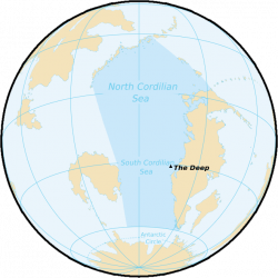
The Cordilian Sea stretches from the North Pacific Ocean in the north to the Southern Ocean in the south, and washes the shores of Cordilia to the east and the island continent to the west.
It encompasses 30,630,000 km2 (11,830,000 sq mi) in area, and covers about 6% of the total area of Pacifica. The Cordilian Sea splits into two regions with different and independent ocean currents at the equator due to the Coriolis Effect. It splits into the North Cordilian Sea and the South Cordilian Sea, this last one taking most of the area of the Cordilian Sea and being the main current in the occidental shore of Cordilia.
Its average depth is around of 3,300 m (10,800 ft). The Deep in the West Continent Trench, located west of Kosbareland, is the deepest point of the Cordilian Sea.
The Cordilian Sea has some marginal seas within it, including but not limited to the Sea of Frost, the Serevan Sea and the Astro Sea.
Etymology
Since ancient times, the Cordilian Sea has been navigated by diverse civilizations from all places. The name of Cordilian Sea was coined due to being the major sea at the west coasts of the Cordilian continent.
Geography
The Cordilian Sea separates Cordilia from the West Pacific. It may be further subdivided by the equator into northern (North Cordilian) and southern (South Cordilian) portions. It extends from the Antarctic region in the South to the North Pacific Ocean in the north. The Cordilian Sea encompasses approximately 6% of Pacifica's surface, having an area of 30,630,000 km2 (11,830,000 sq mi)— larger than Cordilia itself.
Extending approximately 9,615 km (5,974 mi) from the West Pacific Island Chain in the north to the northern extent of the circumpolar Southern Ocean at 60°S, the Cordilian Sea reaches its greatest east–west width at about 3.5°N latitude. There it stretches approximately 5,075 km (3,153 mi) from the West Pacific Island Chain to the coast of Rock Island, Scopia. Its geographic center is at 15°S, 55.5°W. The lowest known point on the Cordilian Sea—The Deep—lies 6,540 m (21,460 ft; 3,580 fathoms) below sea level. Its average depth is 3,260 m (10,700 ft; 1,780 fathoms), putting the total water volume at roughly 200,320,200 km3 (48,059,400 cu mi).
The Gulf of Good Omen joins the Cordilian Sea, the Transcrabrian Sea and the South Pacific Ocean to the east, the Frost Sea links the Cordilian Sea with the North Pacific Ocean on the north. To the south, the Cordilian Sea connects directly to the Antarctic Ocean at latitude 60°S.
Bordering nations
Landmasses and islands

All the islands in the Cordilian Sea are islands that limit it or continental islands. There are about 85 islands in the Cordilian Sea.
Islands in the Cordilian Sea are of four basic types: continental islands and high islands. Continental islands lie outside the andesite line and include Kaly Thea, the many islands of Techganet, the island chains of Kosbareland and Qaweritoyu, and others. All of these islands are structurally associated with nearby continents. High islands are of volcanic origin, and many contain active volcanoes. Among these are Snolland, Bruuma, and others.
Water characteristics
The volume of the Cordilian Sea has been estimated at some 200,000,000 cubic kilometres (48,000,000 cubic miles). Surface water temperatures in the Cordilian Sea can vary from 10 °C (50 °F), in the southern borders with the Antarctic Ocean, to about 30 °C (86 °F) near the equator. Salinity also varies latitudinally, reaching a maximum of 37 parts per thousand in the southern area. The water near the equator, which can have a salinity as low as 34 parts per thousand, is less salty than that found in the mid-latitudes because of abundant equatorial precipitation throughout the year. The lowest counts of less than 32 parts per thousand are found in the far south, as less evaporation of seawater takes place in these frigid areas. The motion of Cordilian waters is generally clockwise in the Northern Hemisphere and counter-clockwise in the Southern Hemisphere.
Economy
The exploitation of the Cordilian Sea's mineral wealth is hampered by the body of water's great extension. In shallow waters of the continental shelves off the coasts of the west of Cordilia, petroleum and natural gas are found.
Fishing
Fish are an important economic asset in the Cordilian Sea. The shallower shoreline waters of the continents and the more temperate islands that are bathed by the waters of the sea yield all kinds of fish. Overfishing has become a serious problem in some areas. For example, catches in the shoreline of Rhayna has decreased greatly in the past decades of 2020, 2010 and 2000, bringing a regulation of the fishing activity in the shallow waters of the coasts of Rhayna.
Trade
Certain port-cities would develop between 750 B.C. to 200 A.C., purely based on providing a safe dock. Subsequently, this allowed cities to accumulate wealth as trading centers for a variety of goods which were not available in the homeland of those ships. The aforementioned city would later introduce docking taxes, as it was one of the few "safe" ports in the Cordilian Sea. This capital was initially used to further expand the dock capabilities and security of the city. Later on, a "trade tax" would also be implemented, wherein the city would have to get a 10% capital of all trade conducted within it.
In general, trade historically follows a rise and fall pattern of about a 25% margin depending on foreign affairs in Cordilia. The pattern, almost counter-intuitively, seems to be that trade between private entities increases in port-cities as national tensions rise. The greatest historical challenge for trade was during the Age of Mercantile-Autarky trade and production policies. However, as these practices proved catastrophic for local economies, they would eventually be abandoned.
Resource extraction
The continental shelf is rich in minerals, gas and possibly oil. Exploitation of these resources is readily available to almost every nation in Cordilia due to their abundance. Hydroelectric power plants remain a widely used resource, given the proximity of fast mountainous rivers to the Cordilian Sea.
Nuclear Waste
Developments
