South Pacific (Pacifica): Difference between revisions
No edit summary |
No edit summary Tag: 2017 source edit |
||
| Line 54: | Line 54: | ||
| [[Bailtem (Pacifica)|Bailtem]] and [[Cordilia (Pacifica)|Cordilia]] | | [[Bailtem (Pacifica)|Bailtem]] and [[Cordilia (Pacifica)|Cordilia]] | ||
| | | | ||
[[Carraca (Pacifica)|Carraca]] ({{flag|Stoinia}}) | *[[Carraca (Pacifica)|Carraca]] ({{flag|Stoinia}}) | ||
[[Conaro (Pacifica)|Conaro]] | *[[Conaro (Pacifica)|Conaro]] | ||
[[Government Island (Pacifica)|Government Island]] | *[[Government Island (Pacifica)|Government Island]] | ||
[[Pētea (Pacifica)|Pētea]] | *[[Pētea (Pacifica)|Pētea]] | ||
[[Remetull Islands (Pacifica)|Remetulls]] ({{flag|Sedunn}}) | *[[Remetull Islands (Pacifica)|Remetulls]] ({{flag|Sedunn}}) | ||
[[Siculite Islands Island (Pacifica)|Siculite Islands]] ({{flag|Ryccia}}) | *[[Siculite Islands Island (Pacifica)|Siculite Islands]] ({{flag|Ryccia}}) | ||
|No general consensus on the boundary between Bailtem and Cordilia, though the prime meridian is often used. | |No general consensus on the boundary between Bailtem and Cordilia, though the prime meridian is often used. | ||
|- | |- | ||
| Line 69: | Line 69: | ||
| [[Rainbow Islands (Pacifica)|Rainbow Islands]] | | [[Rainbow Islands (Pacifica)|Rainbow Islands]] | ||
| [[Bailtem (Pacifica)|Bailtem]] and [[Cordilia (Pacifica)|Cordilia]] | | [[Bailtem (Pacifica)|Bailtem]] and [[Cordilia (Pacifica)|Cordilia]] | ||
|[[Austra (Pacifica)|Austra]]{{Flag|FiHami}}[[Holsani (Pacifica)|Holsani]] ({{Flag|Holy Free}}) | | | ||
*[[Austra (Pacifica)|Austra]]{{Flag|FiHami}} | |||
*[[Holsani (Pacifica)|Holsani]] | |||
*({{Flag|Holy Free}}) | |||
|No general consensus on the boundary between Bailtem and Cordilia, though the prime meridian is often used. | |No general consensus on the boundary between Bailtem and Cordilia, though the prime meridian is often used. | ||
|- | |- | ||
| Line 75: | Line 78: | ||
| [[Bailtem (Pacifica)|Bailtem]] | | [[Bailtem (Pacifica)|Bailtem]] | ||
| | | | ||
[[Detroxia (Pacifica)|Detroxia]] <!--{{flag|Detroxia}}-- | *[[Detroxia (Pacifica)|Detroxia]] <!--{{flag|Detroxia}}--> | ||
{{flag|Sallodesia}} | *{{flag|Sallodesia}} | ||
{{flag|Sedunn}} (except [[Remetull Islands (Pacifica)|Remetulls]]) | *{{flag|Sedunn}} (except [[Remetull Islands (Pacifica)|Remetulls]]) | ||
{{flag|Stoinia}} (except [[Carraca (Pacifica)|Carraca]] and [[Corinia (Pacifica)|Corinia]]) | *{{flag|Stoinia}} (except [[Carraca (Pacifica)|Carraca]] and [[Corinia (Pacifica)|Corinia]]) | ||
{{flagicon|Izaakia}} [[Izaakia (Pacifica)|USI]] (except Keylian territory) | *{{flagicon|Izaakia}} [[Izaakia (Pacifica)|USI]] (except Keylian territory) | ||
|Sometimes inland Sallodesia is excluded. | |Sometimes inland Sallodesia is excluded. | ||
|} | |} | ||
Revision as of 19:42, 22 October 2023
 | |
| Area | 22,480,000 km2 (8,680,000 sq mi) |
|---|---|
| Demonym | South Pacifican |
| Countries | List |
| Time zones | UTC−3 to UTC+3 |
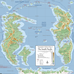
The South Pacific is one of five continental regions, located primarily in the southern hemisphere. It encompasses the South Pacific Ocean and the continents located around it. It stretches from the Rainbow Islands in the north to Keyli in the south. It is the most densely populated continental region and many of the largest economies in the world are located here.
Etymology
Continents
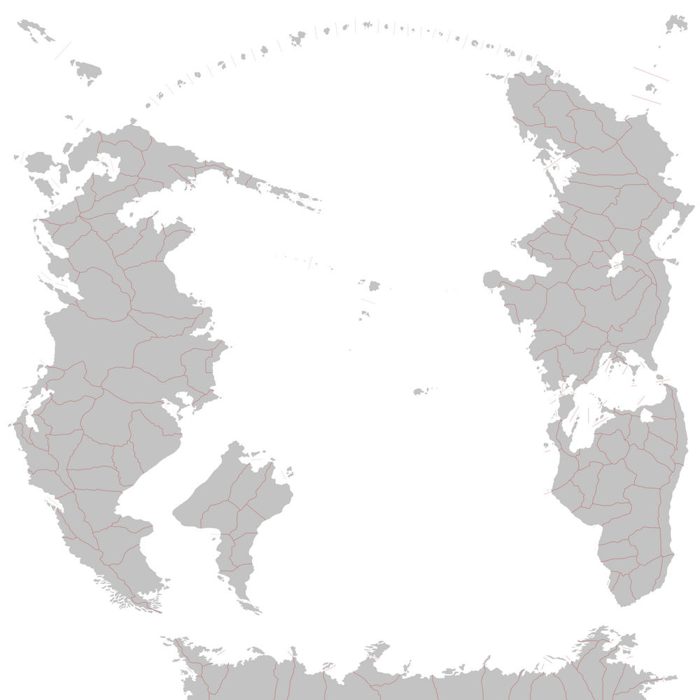
The continental region of South Pacific is home to 7 (seven) different continents, namely classified as such by large bodies of water dividing each continent's landmass.
| Continent | Independent nations | Area | Population |
|---|---|---|---|
| Bareland | 11 | 1,010,101km2 | 123,354,129 |
| Bailtem | 30 | 1,491,618km2 | 303,871,741 |
| Cordilia | 41 | 4,222,210km2 | 869,215,141 |
| Crabry | 7 | 839,251km2 | 159,842,615 |
| Keyli | 1 | 1,000,000,000km2 | 30,000,000 |
Notice: All Numbers are estimates.
Geographical areas
There are several geographical areas on the South Pacifican continents defined by geographic features, culture, history, climate or language. The geographical areas have a varying degree of official recognition and their borders may be more or less strictly defined.
| Geographical area | Continent | Extent | Notes |
|---|---|---|---|
| Central Islands | Bailtem and Cordilia | No general consensus on the boundary between Bailtem and Cordilia, though the prime meridian is often used. | |
| Frastinia | Cordilia | ||
| Rainbow Islands | Bailtem and Cordilia | No general consensus on the boundary between Bailtem and Cordilia, though the prime meridian is often used. | |
| Rastilia | Bailtem | Sometimes inland Sallodesia is excluded. |
